News outlets across the country are struggling with the fact that this hurricane season has been mild. How does the corporate media deal with this “problem?”
They double down, claiming the hurricanes haven’t hit yet, but they’re coming. A Google search for “hurricanes” brings a plethora of articles saying that the hurricane season will still be catastrophic despite the lack of catastrophic hurricanes. it’s fearmongering at its worst.
The Climate Change Roundtable crew covers the claim that hurricanes are increasing in frequency and severity. The crew also comments on a few videos from Vice President Kamala Harris focused on climate change. Finally, they check out the plethora of articles about how certain areas of the globe are warming faster than others.
Check out Climate Change Roundtable, live every Friday at 12pm CT.
LIVE LINK:
The year so far..
https://realclimatescience.com/2022/08/all-weather-is-now-climate-change-2/
Atlantic Year 2022 Hurricane Data from Colorado State University through August 5, 2022 shows that Accumulated Cyclone Energy for year 2022 is now only 25% of the average Accumulated Cyclone Energy for this seasons time period relative to average for the period 1991 to 2020 as well as having only 3.25 days of actual storm activity compared to about 10 days for the average over this 1991 to 2020 period.
Clearly a very slow start regardless of how NOAA is trying to spin this outcome.
http://tropical.atmos.colostate.edu/Realtime/
Based on the above hurricane chart we have not, in any measurable way, had a slow start in our (desired) bad weather.
Very helpful chart.
Latest Euro monthly operational only shows a couple minor storms in the Atlantic through 9-5-22. If this verifies, going to be hard to have an “above average ” season (objectively measured via ACE index) in the Atlantic – just too deep into the season without enough activity to date.
My theory : Blob of cold water north of the main development region (MDR) may be at play . Colder temps = higher pressures to north = stronger pressure gradient with MDR = stronger easterlies in the low levels = more shear = less storm development
Their tactic has been clear for the last few years. Lacking actual hurricanes they name everything they think they can get away with so that the ACE of named tropical storms has dropped significantly over the last few years.
They already did it this year and messed with the residents and visitors to the shores of the Carolinas over the 4th of July weekend by naming a nothingburger COLIN. The highest windspeed I could find reported by a shore station was 37 mph. And even after it had dissipated the NHC continued the hype putting tropical storm warnings out for the coast of N. Carolina.
Their forecast:
Tropical Storm Colin to impact NC Coast (msn.com)
It was total Bull!
Thus why using the ACE index is important- Colin racked up next to no ACE points. ACE index avoids “naming inflation “ issues
Today in NZ we have 120kmh winds (75mph) in Wellington and in the South Island high country 160kmh (100mph). We do name these. Our name is “Bloody weather!!”
Actually Richard that’s pretty normal for Windy Wellington isn’t it! On the very edge of Cook’s Strait it’s a great funnel for winds between the North and South Islands as you know.
I agree.
The Atlantic gets the most press, but it isn’t the only ocean.
The Northeast Pacific is ahead of schedule as is the South Indian, but the Northwest Pacific, North Indian, and South Pacific are behind schedule.
Cyclone activity
That could turn around in less than a month, but if it does, it will be weather. If it doesn’t it will still be weather, because one cannot make climate pronouncements based on a few months of data.
The multi-year data demonstrates that cyclonic activity is not growing as some warmists predict.
Warmists can’t get anything right.
The next move will be to claim that a lack of hurricanes is, in-itself, extreme weather.
Ummmm . . .
“Relative to neutral events, the frequency of hurricane landfalls along the East Coast is found to increase (decrease) during ENSO cold (warm) events. This is consistent with previous studies linking ENSO and Atlantic hurricane activity.” — Regional Effects Of ENSO On U.S. Hurricane Landfalls, https://climatecenter.fsu.edu/topics/tropical-weather/regional-effects-of-enso-on-us-hurricane-landfalls )
The ENSO meter graphic on the right side, about midway down this webpage, shows that the ENSO index is currently in neutral territory, which represents a trending toward an ENSO warm event compared to the index value at the beginning of 2022. —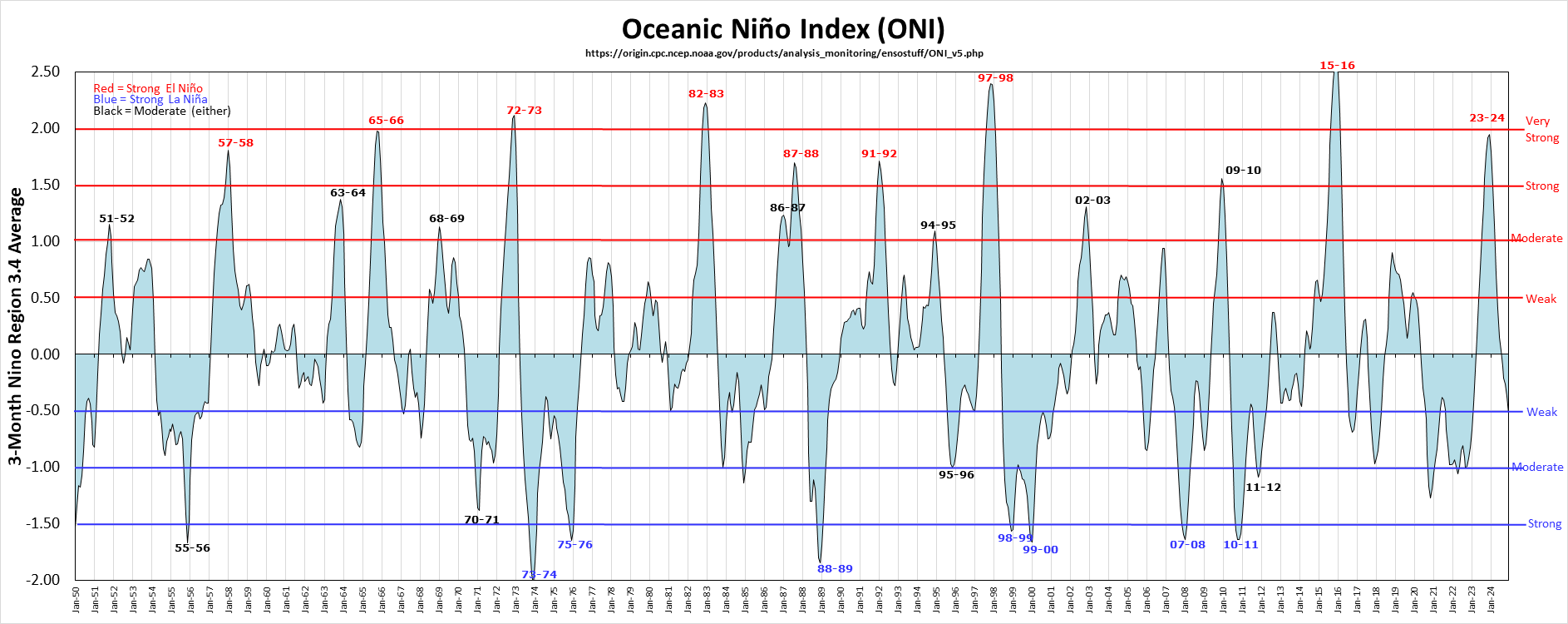
While that adage “past performance is no guarantee of future results” is true, the past still may be used to estimate the future.
I fear that this is not the end of “climate change.”
What would people talk about in elevators all over the world if the weather stayed uneventful?
I mean, we can only regurgitate what the Kardashians have been up to so many times, right?
MEI at record low for this time of year. What will happen in November?
https://drive.google.com/file/d/1OFB3GczUOmJ-T1IwbmVFa3NuRaWpSIaO/view
http://www.bom.gov.au/cgi-bin/oceanography/wrap_ocean_analysis.pl?id=IDYOC007&year=2022&month=08
The peak of the Atlantic hurricane season is Sept. 10th.
A graph is easily found, so there is plenty of time. I’ll describe the season
after Thanksgiving dinner.
The real importance of these storms is that they bring most of the
precipitation to the SE and S. Central regions of the USA. We can
hope that this is always just slightly above average, but it doesn’t
work that way.
What the negative surface temperature anomalies of the tropical North Atlantic tell us.

Yep! Look at those too cool SSTs coming off Africa along the path of the MDR. Along that path is also dust being pushed off the Sahara all the way to the Caribbean.
The look at the SSTs along the East Coast of the US and the Gulf. That means the best potential is for close in development.
And personally, in the opinion of this truck driver, the best potential is for development that hits the east coast because the easterlies have been causing sheer further south.
The thing is though that whole picture could change in a couple weeks.
After the climatistas decided to replace dire warnings of future post-1.5°C apocalypse (which wasn’t working so well), they evolved the message that “climate change is happening now”. They hype every weather event as evidence of (anthropogenic, catastrophic) climate change. And of course they are usually “unprecedented”.
A relatively recent variation on this theme, is to hype weather events before they actually happen (just in case they don’t happen). The recent “unprecedented” 40°C heatwave in the UK was being hammered out on every news outlet for days before they were able to find a 40°C reading. The Met Office featured warnings of people dropping like flies if they ventured out into the sunshine. I know some people who believed it all, so as a tactic, it appears to get better traction than waiting till it’s over and no one has dropped dead in the street.
So a bad Atlantic hurricane season is today’s fear-mongering topic. Once they’ve departed from any semblance of factual reporting, it comes down to the story, and “experts say”. In Canada, we are being told that this year’s fire season will be a really bad one, although so far it looks quite normal.
It’s all part of the softening up process so that the people will accept the net-zero “solution” that’s starting to be imposed on them.
I did some quick research on NOAA Hurricane predictions just yesterday. Since 2006, there has been no instance where NOAA predicted a quiet hurricane season. Yet, quiet seasons were not uncommon during that time period. That is fear mongering.
“Since 2006, there has been no instance where NOAA predicted a quiet hurricane season.”
Yes, Hurricane Kartina hit New Orleans in 2005, and for 12 years after Katrina, there were no major hurricanes that hit the United States, yet as you point out, NOAA predicted an above average hurricane season every year during those 12 years.
Based on what, NOAA? Why should we have faith in your future predictions?
“it’s fearmongering at its worst.”
That’s all the alarmists have is to promote fear.
“Fear is the path to the Dark Side. Fear leads to anger. Anger leads to hate. Hate leads to suffering.” -Yoda
I must not fear. Fear is the mind-killer. Fear is the little-death that brings total obliteration. I will face my fear. I will permit it to pass over me and through me. And when it has gone past I will turn the inner eye to see its path. Where the fear has gone there will be nothing. Only I will remain.
Bene Gesserit Litany against Fear.
Nice Dune reference😉
Long time since I read Dune. Nice prayer our politicians could learn to recite.
you know they will just keep updating/adjusting their prediction….and by Nov they will be exactly right…
….same way they predict where one is going
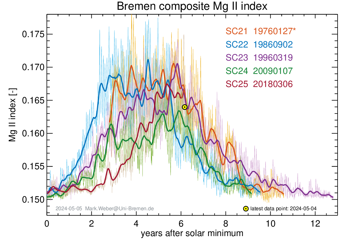
Is the first peak in this solar cycle behind us?
They just don’t like good news. It makes them irrelevant
The models associate hurricanes with warmer oceans, on the basis that more energy in the ocean means more energy for hurricanes. Earth itself seems to associate hurricanes with cooler oceans, because a greater temperature difference between cooler northern oceans and constant tropical oceans is what drives hurricanes.
In other words, the models get hurricanes wrong.
Klotzbach and Gray did a nice chart showing this very clearly in their (from memory) 2008 State of the Climate report.
The temperature differences in the atmosphere in North America influence the severity of the storms (think tornadoes) in the mid-to-eastern USA.
The Atlantic Ocean storms begin as “Easterly Waves” near Africa and need to be enough north that the motion will rotate (Coriolis effect). Deep warm water is a source of energy. Before and after passage the sea surface temperatures will show the removal of the energy.
Winds from the west (at the right elevation) will shear the top from the developing storm.
Weather Facts: Easterly wave – the Hurricane’s cradle | weatheronline.co.uk
What does the “removal of the energy”? Evaporation, convection, conduction, replacement by cooler northern water??
Evaporation (sunlight & warm water) produces water vapor that is convected upward until cooling begins that releases energy and adding more lift. The rotation brings more moist air from a bigger area allowing the system to grow.
While I did not examine the following article well, it seems good:
What Is the Latent Heat of Condensation? (reference.com)
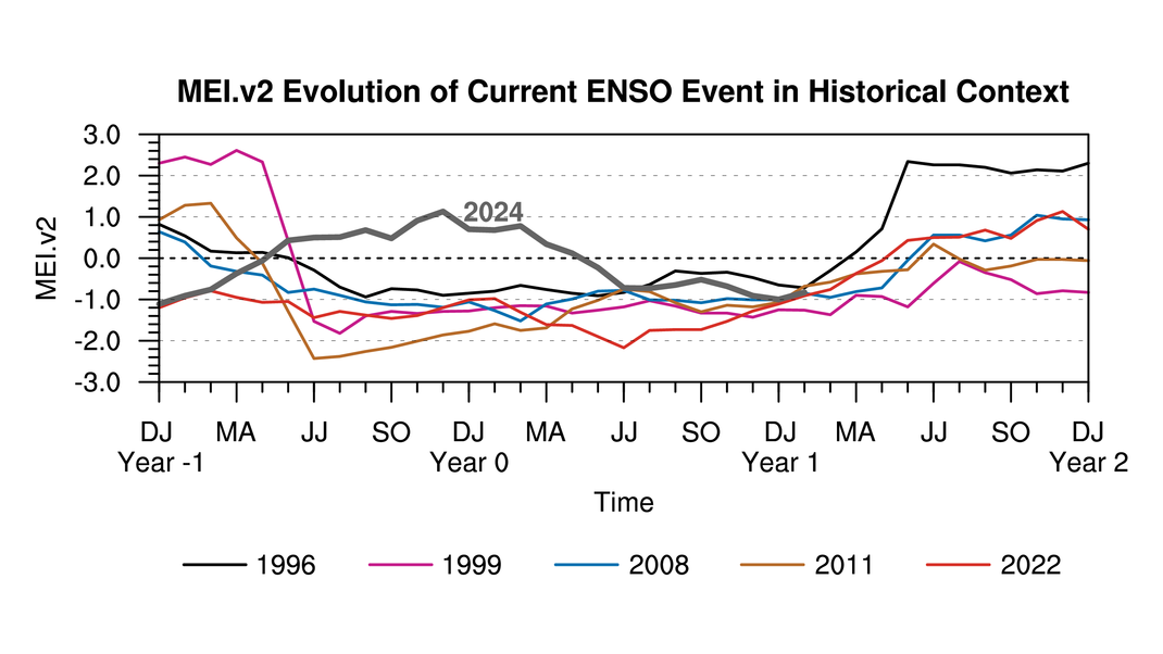
Ryan Maue sees 2000 as an analogue to 2022. Very similar.
https://mobile.twitter.com/RyanMaue/status/1546633681447620609
“ 2000 shows up as an “analog” year or similar climate as 2022, especially with triple dip La Niña.
December 2000 was very cold across Eastern 2/3 of the United States. Can we put much confidence in such a prediction for this next winter?”
This is also 22 years ago, putting us roughly in the same phase and polarity of the solar cycle. We also just had the weakest solar cycle in over a century.
Here is wikipedia on the 2000 hurricane season. https://en.m.wikipedia.org/wiki/2000_Atlantic_hurricane_season
“ The 2000 Atlantic hurricane season was a fairly active hurricane season, but featured the latest first named storm in a hurricane season since 1992. The hurricane season officially began on June 1, and ended on November 30. It was slightly above average due to a La Niña weather pattern although most of the storms were weak. It was also the only Season to Include 2 storms in Ireland. The first cyclone, Tropical Depression One, developed in the southern Gulf of Mexico on June 7 and dissipated after an uneventful duration. However, it would be almost two months before the first named storm, Alberto, formed near Cape Verde; Alberto also dissipated with no effects on land. Several other tropical cyclones—Tropical Depression Two, Tropical Depression Four, Chris, Ernesto, Nadine, and an unnamed subtropical storm—did not impact land. Five additional storms—Tropical Depression Nine, Florence, Isaac, Joyce, and Leslie—minimally affected land areas.
The most significant storm of the season was Hurricane Keith, which caused extensive damage in Central America. After remaining nearly stationary offshore, Keith moved inland over the Yucatán Peninsula and later made a second landfall in Mexico at hurricane intensity. It caused $319 million (2000 USD) in damage and 40 fatalities, mostly in Belize. The precursor to Tropical Storm Leslie brought severe flooding to South Florida, which losses reaching $950 million (2000 USD). Hurricane Gordon and Tropical Storm Helene both caused moderate damage in the Southeastern United States, mainly in Florida. Tropical Storm Beryl caused minor damage in Mexico and Hurricane Debby resulted in less than $1 million (2000 USD) in damage in the Greater and Lesser Antilles. Hurricane Michael brought widespread effects to Atlantic Canada, though a specific damage toll is unknown.“
December 2000 was very cold across Eastern 2/3 of the United States. Can we put much confidence in such a prediction for this next winter?”
Joe Bastardi has already said to get ready for a colder December than we have seen in the US in the last several years. During those years December has been considerably warmer than the averages for much of the US.
Ok, I am way out of my depth with this, but the Microwave Limb Sounder instrument on NASA’s Aura satellite, which measures atmospheric gases, found that the Tonga underwater volcanic eruption earlier this year delivered roughly 146 teragrams of water to the stratosphere, between about eight and 33 miles above the planet’s surface. One teragram equals a trillion grams, and that extreme quantity increased the total amount of water in the stratosphere by about 10%.
So, two questions, what will be the impact of this on hurricane formation, and how will it affect the weather over the next few months?
My gut feeling is that the water vapor will absorb solar energy and may somewhat warm the top of the troposphere. That would reduce the potential energy of a hurricane, since it is dependent upon a cold upper troposphere.
Change in weather is a little tricker. Seems like all that water vapor is eventually going to come back down, so global precipitation might be up just a smidgen, but what about temps? Will it warm everything up a bit, or will it prevent some solar energy from reaching us by absorbing some energy that would otherwise reach lower levels and re-radiating half of it back into space, resulting in some cooling of the troposphere?
Or is this amount of water vapor too small to make any measurable difference?
Well it’s looking like in 8-10 days we’re likely to see the Atlantic basin find its TS legs. Weather patterns are going to be conducive for landfall on the US. And with the higher than average SSTs all along the eastern and gulf coasts close in intensification is likely. So get ready for the braying of climate doom from the usual jackasses.
An Easterly Wave is now — Aug 7th — off the coast of Guinea-Bassau.
It will be mid-week before much will be known about this.
National Hurricane Center (noaa.gov)
That Wave disappeared. There are minor disturbances still but as of 8/11, the next 48 hours is not expected to develop into tropical cyclone activity.
So, still waiting.