


Credit: concernusa.org
Even the normally alarmist BBC has to admit that ‘a La Niña event normally exerts a cooling influence on the world’. Add in a deep solar minimum and things could get interesting, with varying regional effects.
– – –
A moderate to strong La Niña weather event has developed in the Pacific Ocean, according to the World Meteorological Organization (WMO).
The naturally occurring phenomenon results in the large scale cooling of ocean surface temperature, says BBC News.
This La Niña, which is set to last through the first quarter of 2021, will likely have a cooling effect on global temperatures.
But it won’t prevent 2020 from being one of the warmest years on record.
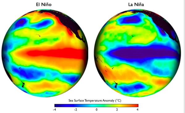
La Niña is described as one of the three phases of the weather occurrence known as the El Niño-Southern Oscillation (ENSO).
This includes the warm phase called El Niño, the cooler La Niña and a neutral phase.
A La Niña develops when strong winds blow the warm surface waters of the Pacific away from South America and towards Indonesia.
In their place, colder waters from deep in the ocean come up to the surface.
This event leads to significant weather changes in different parts of the world.
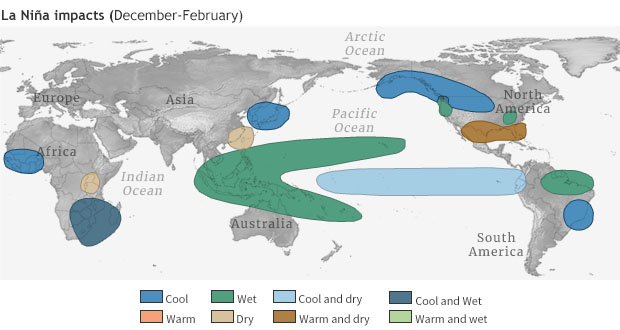
If a really strong La Niña event were to occur, research suggests that the UK and Northern Europe might experience a very wet winter.
Normally La Niña means countries like Indonesia and Australia can get much more rain than usual, and a more active monsoon occurs in southeast Asia.
There are likely to be more storms in Canada and the northern US, often leading to snowy conditions.
Southern US states can be hit by drought at the same time.
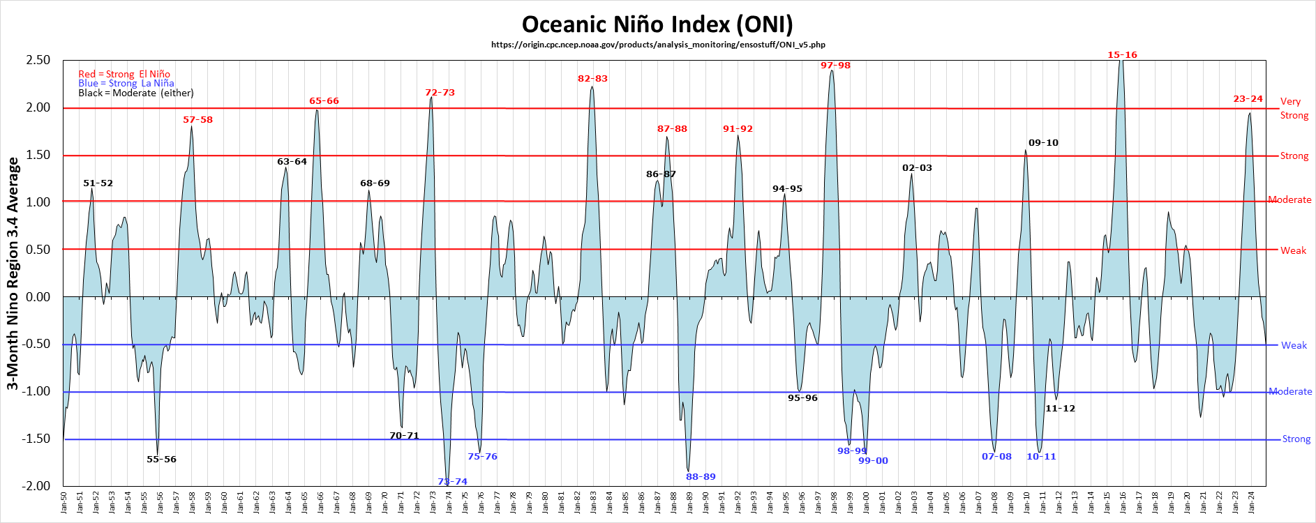
The last time that a strong event developed was in 2010-2011.
The WMO says there is a now around a 90% chance of tropical Pacific sea temperatures remaining at La Niña levels for the rest of this year.
There is a 55% chance of the conditions persisting through the first quarter of next year.
While a La Niña event normally exerts a cooling influence on the world, this is unlikely to make too much of a difference to 2020.
Full article here.

No La Niña of note for nearly a decade (‘strong’, see lowest panel, blue type).
[click on image to enlarge]
The BBC news this evening added on at the end of this report a nonsense statement from some alarmist bloke saying that the temperature involved by this event was too small to affect the march of global warming. (Or words to that effect).
Rampant bias – converting a news item into a propaganda opinion to avoid anyone contemplating having doubts about the CAGW Meme which has now gone viral.
I think the BBC is saying this to cover themselves when global warming doesn’t occur as predicted. They cannot openly admit that there is natural climate change.
“A La Niña develops when strong winds blow the warm surface waters of the Pacific away from South America…”
I wasn’t aware that the Humboldt current was warm. I thought that in a el nińo it was warm surface waters being pushed towards Sth. America that caused the torrential rain in Peru etc. You learn something different from the BBC.
In the last few days there has been torrential rain in Qld. and northern NSW and some of the NT. Even down here in Adelaide we have had some rain in the past week. So they got something right.
Reblogged this on Climatism and commented:
Mother Nature, determining our short-term weather and long-term climate outcomes? Preposterous! /sarc
As an Australian and Queenslander, I take more note of the SOI and IPO, look at this site https://www.longpaddock.qld.gov.au/rainfall-poster/ where you can download poster of rainfall and cyclone tracks for every year back to 1910. At bottom of the posters there is a running chart of SOI and IPO. It will be noted that the IPO has a period of something like 30 years and at present we are in a positive or drier phase. Very wet and floods in Qld occur when the SOI is strongly positive (ie >10) and IOP is negative (eg 2011&1974). That coincides with a strong La Nina. A strong El Nino (ie drought & hot) is indicated by the opposite sign of SOI & IPO. (eg 1998, 1942). I believe the AMO has a similar period to the IPO. However, the non-science climate alarmists do not want to know anything about periodic oscillations. BTW with a period of 30 years one needs about 120 years of data to even start to look at variability.
Graeme – ‘I wasn’t aware that the Humboldt current was warm.’
– – –
The next line after your quote says:
In their place, colder waters from deep in the ocean come up to the surface.
That’s the Humboldt current.
So this exerts a cooling effect but it’s opposite doesn’t exert a warming effect? Amazing how these things work in ClimateWorld.
El Niño in 2015-16 ended ‘the pause’ – remember that one?
– – –
Typical winter (December–February) temperature and precipitation impacts from La Niña. Map by climate.gov.
oldbrew:
The Humboldt current is the ‘normal’ state off the coast of Peru bringing drier weather there, but very good fish harvests (as also guano deposits on islands off-shore). It is El Niño that drives warmer weather onshore there, destabilising agriculture and fishing for short periods for (at least) hundreds of years.
If La niña is responsible for ‘driving warm waters’ westwards why didn’t it? It could be due to an end to the el niño and reversion to the ‘normal’ state rather than any positive action. It is a cyclic weather thing with no apparent connection with global warming (or whatever it is called this week).
I must admit, thanks to little exposure to the BBC, a certain inability to decipher BBCTalk. I think this was inaugurated by Humpty Dumpty.
It is a ‘prediction’ derived from my work that changes in solar activity will shift the balance between El Nino and La Nina events over two or more consecutive solar cycles.
A persistently quiet sun eventually leads to more La Ninas, wavier jet stream tracks, greater global cloudiness, less solar energy into the oceans and a cooling world.
The past ten years with very few La Ninas was probably the last effect from the late 20th century warming period. That absence of La Ninas allowed atmospheric temperatures to remain pretty much flat despite declining solar activity.
UK weather: torrential rain could cause ‘dangerous’ flooding this week
Wed 28 Oct 2020
“It could be the case that the next few days of rain could make this one of the wettest Octobers London has had.”
. . .
People in Britain have also been warned life-threatening floods could impact certain regions over the weekend, as more rain falls on the already saturated ground. The unusual amount of rain is the result of low pressure moving in from across Atlantic. [bold added]
https://www.theguardian.com/uk-news/2020/oct/28/uk-weather-torrential-rain-dangerous-flooding
oldbrew, it sounds to me that they are saying councils have been cutting back on storm drain maintenance as well ad river dredging again. If there is flooding then the ‘climate scientists’ are responsible because they keep on saying it isn’t going to happen any time soon and fools believe them.
Instead of arguing about El Nino and La Nina read my comment above and goto to the web site https://www.longpaddock.qld.gov.au/rainfall-poster/ , then down load the poster on the right “Australia’s variable rainfall with Tropical cyclone tracks. Expand the poster to at least 75% and look at the right side
. It explains El Nino, La Nina and ENSO neutral. Also note the graphs of SOI and IOP at the bottom. I suggest we are not in a significant La Nina mainly because the IPO is in the +ve phase.
If you want to consider rainfall in UK look at AMO graphs. I do not know if AMO is linked to the IPO in some way but I have noted they have similar periodic trends of about 30 years which does not fit with the sun spot cycle or the orbit of Jupiter. It maybe there is another planet alignment.
OCTOBER 29, 2020
‘Moderate to strong’ La Nina this year: UN
The last La Nina, which was brief and relatively weak, began developing in November 2017 and ended in April 2018, according to WMO.
This year’s La Nina “is expected to be moderate to strong”, WMO said, adding that the world had not seen a strong La Nina for a decade.
WMO stressed though that La Nina and El Nino were not the only factors driving global and regional climate patterns, and that “no two La Nina or El Nino events are the same”.
https://phys.org/news/2020-10-moderate-strong-la-nina-year.html
Solar cycle 25 isn’t developing, or at least not the way solar cycle 24 did?
Wikipedia says: Numbers in brackets for cycle 25 indicate the minimum possible value for that month, assuming there are no more sunspots between now (2 Nov 2020) and six months after the end of the month in question.
Source: https://en.wikipedia.org/wiki/List_of_solar_cycles
With La Nina in the Pacific now officially started, it will take several months for that surface cooling to be fully realized in the tropospheric temperatures. Typically, La Nina minimum temperatures (and El Nino maximum temperatures) show up around February, March, or April.
https://www.drroyspencer.com/2020/11/uah-global-temperature-update-for-october-2020-0-54-deg-c/