File:Perchtoldsdorf Pfarrkirche Türkenfenster 01.jpg
Jump to navigation
Jump to search

Size of this preview: 135 × 600 pixels. Other resolutions: 54 × 240 pixels | 108 × 480 pixels | 173 × 768 pixels | 230 × 1,024 pixels | 461 × 2,048 pixels | 3,495 × 15,524 pixels.
Original file (3,495 × 15,524 pixels, file size: 27.53 MB, MIME type: image/jpeg)
Captions
Captions
Add a one-line explanation of what this file represents
Summary[edit]
| Description |
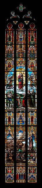
Deutsch: Türkenfenster der Pfarrkirche Perchtoldsdorf, Niederösterreich
English: Turks Window at the parish church Perchtoldsdorf, Lower Austria
Español: Ventana turca en la iglesia parroquial de Perchtoldsdorf (Baja Austria).
Magyar: A perchtoldsdorfi plébániatemplom törökablaka, mely az 1683. július 16-i bécsi csata során lerombolt várost ábrázolja (Mödlingi járás, Alsó-Ausztria)
Македонски: Црковен прозорец во Перхтолдсдорф, Долна Австрија. На него е прикажано опустушувањето на гратчето од Османлиите при Опсадата на Виена во 1683 г.
Nederlands: Het Turkenvenster in de plaatselijke parochiekerk toont de verwoesting van Perchtoldsdorf in Neder-Oostenrijk op 16 juli 1683, tijdens het (tweede) beleg van Wenen
Português: Janela turca na igreja paroquial de Perchtoldsdorf (Baixa Áustria), que mostra a destruição da cidade durante a Batalha de Viena em 16 de julho de 1683
Čeština: Mozaikové Turecké okno farního kostela ve městě Perchtoldsdorfu (Dolní Rakousy) zobrazuje poničení města ze 16. července roku 1683 během druhého obléhání Vídně.
Эрзянь: «Туркань вальма» (Turks Window) Перхтольдсдорф (Алце Австрия) савксонь церкувасо, конась невти 1683-це иень медьковонь 16-це чинь ошонть чамдоманть, кона ульнесь Вена вакссо туремасонть.
|
| Date | |
| Source | Own work |
| Author | Uoaei1 |
| Camera location | | View this and other nearby images on: OpenStreetMap |
|---|

|
NOTE: This image is a panorama consisting of multiple frames that were merged or stitched in software. As a result, this image necessarily underwent some form of digital manipulation. These manipulations may include blending, blurring, cloning, and colour and perspective adjustments. As a result of these adjustments, the image content may be slightly different from reality at the points where multiple images were combined. This manipulation is often required due to lens, perspective, and parallax distortions.
|
Assessment[edit]
This image was selected as picture of the day on Wikimedia Commons for 16 July 2020. It was captioned as follows: English: Turks Window at the parish church Perchtoldsdorf (Lower Austria), illustrating the devastation of the town on 16 July 1683, during the Battle of Vienna Other languages:
Čeština: Mozaikové Turecké okno farního kostela ve městě Perchtoldsdorfu (Dolní Rakousy) zobrazuje poničení města ze 16. července roku 1683 během druhého obléhání Vídně. Deutsch: Türkenfenster der Pfarrkirche Perchtoldsdorf (Niederösterreich) mit der Darstellung der Zerstörung des Ortes während der Zweiten Wiener Türkenbelagerung am 16. Juli 1683 English: Turks Window at the parish church Perchtoldsdorf (Lower Austria), illustrating the devastation of the town on 16 July 1683, during the Battle of Vienna Español: Ventana turca en la iglesia parroquial de Perchtoldsdorf (Baja Austria), que muestra la destrucción de la ciudad durante la batalla de Kahlenberg el 16 de julio de 1683. Magyar: A perchtoldsdorfi plébániatemplom törökablaka, mely az 1683. július 16-i bécsi csata során lerombolt várost ábrázolja (Mödlingi járás, Alsó-Ausztria) Nederlands: Het Turkenvenster in de plaatselijke parochiekerk toont de verwoesting van Perchtoldsdorf in Neder-Oostenrijk op 16 juli 1683, tijdens het (tweede) beleg van Wenen Português: Janela turca na igreja paroquial de Perchtoldsdorf (Baixa Áustria), que mostra a destruição da cidade durante a Batalha de Viena em 16 de julho de 1683 Македонски: Црковен прозорец во Перхтолдсдорф, Долна Австрија. На него е прикажано опустушувањето на гратчето од Османлиите при Опсадата на Виена во 1683 г. |
|
This image has been assessed using the Quality image guidelines and is considered a Quality image.
|

|
This image has been assessed under the valued image criteria and is considered the most valued image on Commons within the scope: Pfarrkirche hl. Augustinus, Perchtoldsdorf – Türkenfenster. You can see its nomination here. |
Licensing[edit]
I, the copyright holder of this work, hereby publish it under the following license:
This file is licensed under the Creative Commons Attribution-Share Alike 4.0 International license.
- You are free:
- to share – to copy, distribute and transmit the work
- to remix – to adapt the work
- Under the following conditions:
- attribution – You must give appropriate credit, provide a link to the license, and indicate if changes were made. You may do so in any reasonable manner, but not in any way that suggests the licensor endorses you or your use.
- share alike – If you remix, transform, or build upon the material, you must distribute your contributions under the same or compatible license as the original.
| Annotations | This image is annotated: View the annotations at Commons |
File history
Click on a date/time to view the file as it appeared at that time.
| Date/Time | Thumbnail | Dimensions | User | Comment | |
|---|---|---|---|---|---|
| current | 20:01, 12 December 2018 | 3,495 × 15,524 (27.53 MB) | Uoaei1 (talk | contribs) | User created page with UploadWizard |
You cannot overwrite this file.
File usage on Commons
The following 32 pages use this file:
- User:Eatcha/POTY-2018-Round-1-Results
- User:PetrohsW/Favorites
- User talk:Uoaei1/Archive09
- User talk:Uoaei1/Archive10
- User talk:Uoaei1/Archive12
- Commons:Featured picture candidates/File:Perchtoldsdorf Pfarrkirche Türkenfenster 01.jpg
- Commons:Featured picture candidates/Log/December 2018
- Commons:Featured pictures/Objects/Architectural elements
- Commons:Featured pictures/chronological/2018-B
- Commons:Picture of the Year/2018/Candidates
- Commons:Picture of the Year/2018/R1/Gallery/2018-B
- Commons:Picture of the Year/2018/R1/Gallery/ALL
- Commons:Picture of the Year/2018/R1/Gallery/Frescos, ceilings and stained glass
- Commons:Picture of the Year/2018/R1/Gallery/M12
- Commons:Picture of the Year/2018/R1/v/Perchtoldsdorf Pfarrkirche Türkenfenster 01.jpg
- Commons:Quality images/Subject/Works of art/Archive 2019
- Commons:Quality images candidates/Archives December 16 2018
- Commons:Valued image candidates/Perchtoldsdorf Pfarrkirche Türkenfenster 01.jpg
- File:Perchtoldsdorf Pfarrkirche Innenraum 01.jpg
- File:Perchtoldsdorf Pfarrkirche Türkenfenster 01 (cropped).jpg
- Template:Potd/2020-07
- Template:Potd/2020-07-16
- Template:Potd/2020-07-16 (cs)
- Template:Potd/2020-07-16 (de)
- Template:Potd/2020-07-16 (en)
- Template:Potd/2020-07-16 (es)
- Template:Potd/2020-07-16 (hu)
- Template:Potd/2020-07-16 (mk)
- Template:Potd/2020-07-16 (myv)
- Template:Potd/2020-07-16 (nl)
- Template:Potd/2020-07-16 (pt)
- Template:Potd/2020-07-16 (pt-br)
.jpg)
File usage on other wikis
The following other wikis use this file:
- Usage on be-tarask.wikipedia.org
- Usage on crh.wikipedia.org
- Usage on cv.wikipedia.org
- Usage on fr.wikipedia.org
- Usage on hu.wikipedia.org
- Usage on hy.wikipedia.org
- Usage on ka.wikipedia.org
- Usage on ko.wikipedia.org
- Usage on lbe.wikipedia.org
- Usage on lez.wikipedia.org
- Usage on mg.wikipedia.org
- Usage on mk.wikipedia.org
- Usage on os.wikipedia.org
- Usage on pt.wikipedia.org
- Usage on ru.wikipedia.org
- Usage on ru.wikinews.org
- Usage on sah.wikipedia.org
- Usage on sq.wikipedia.org
- Usage on tt.wikipedia.org
- Usage on vep.wikipedia.org
- Usage on zh.wikipedia.org