Hitting the Books: Searching for ancient cities from space
Wait, no, that's Barstow.


Welcome to Hitting the Books. With less than one in five Americans reading just for fun these days, we've done the hard work for you by scouring the internet for the most interesting, thought provoking books on science and technology we can find and delivering an easily digestible nugget of their stories.
Archaeology from Space: How the Future Shapes Our Past
by Sarah Parcak

When the Soviets sent Sputnik into orbit, they weren't just kicking off the Space Race but ushering in an entirely new era for humanity. Suddenly the stars were within reach and we were afforded the clearest view in history of our home planet. Today, satellites help guide us to our destinations, warn us of inclement weather, and even assist archaeologists as they seek to uncover our shared global heritage.
In this excerpt from Archaeology from Space, National Geographic Explorer and TED Prize-winner Dr. Sarah Parcak explains what examining ancient sites from Low Earth Orbit actually entails and how it can provide some unexpected benefits.
How Space Archaeology Works
Whenever archaeologists apply any form of air- or space-based data to the assessment of modern landscapes, attempting to locate long-buried rivers or hidden ancient sites, they are doing "space archaeology," also called "satellite archaeology" or "satellite remote sensing." NASA shoulders the ultimate name blame. In 2008, NASA began its "Space Archaeology" program,11 funding scientists to apply satellite data sets to large-scale archaeological research projects. If NASA calls what I do space archaeology, who am I to disagree?
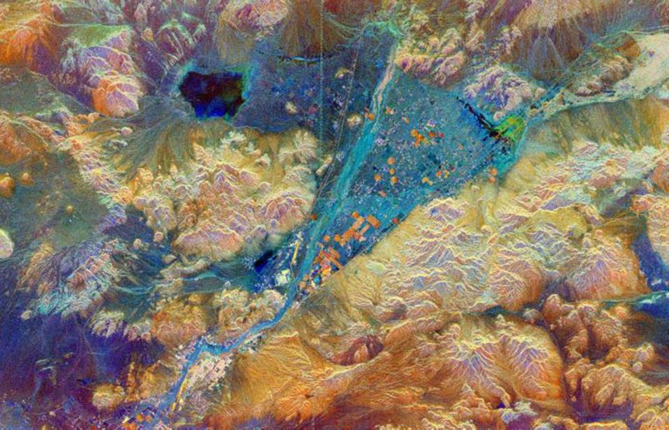
Interpreting satellite imagery is part science and part art. All remote-sensing specialists must start by learning the language of light, and it is not easy: what appears as a simple high-resolution photograph on your computer screen is so much more. Each pixel on the image is representative of an exact area on the ground. The light composing the pixel represents not only the visible part of the light spectrum, but the near, middle, and far infrared, depending on the satellite-imaging system. Additionally, everything on the Earth's surface has its own distinct chemical signature that affects the light it reflects: much as we all have distinct signatures when we write our names, different materials show up uniquely in the light spectrum.
For example, sand appears very different from forest on the satellite imagery. We can see this easily with our own eyes. When you need to discern different tree species within the forest, this is where chemical signatures come into play. A group of oak trees emits a different chemical signature than does a group of pine trees. Visually, they might appear as the same green to us, but using different parts of the infrared spectrum to visualize subtle vegetation health differences, we can perceive color variation.
Remote-sensing specialists can exaggerate these differences by assigning "false color" to the images, to highlight individual classes of surface features. Within remote-sensing programs (like Photoshop color replacement with an attitude), you can choose any color for any cluster of pixels. While it's recommended that users choose classes closely resembling their real-life counterparts—for example, green tones for vegetation, gray for buildings, brown for soils—you can choose any colors you want. Satellite images shown at conferences or in publications sometimes look like bad acid trips.
Scientists shop for specific types of satellite images to suit the data they need. Each satellite is different, and there are over 1,700 of them up there. Most are lower-resolution weather or large-scale satellites, with resolutions of 15 to 30 meters. These are the images most used, not just because they are free, but because there are millions of images going all the way back to 1972 that highlight short- and long-term landscape changes. In addition to these free images, there are high-resolution images recorded by sensors such as DigitalGlobe's WorldView-3 and -4 satellites, with resolutions of between .31 and 1 meter, where a single pixel represents an area between the size of an iPad and a bodyboard. Everyone looking at satellite imagery extracts pixel-based data to detect subtle short-term versus long-term changes, or to detect features. We tweak and test algorithms depending on our research questions, and eventually, through sheer dumb luck or a moment of genius, we find something of interest, usually because we're scraping the barrel bottom of possible techniques. When it turns out to be dried snot on our computer screen, this being science, we go back to the drawing board and try again.
It Isn't All "Aha" Moments, Except When It Is
People think that remote-sensing work is all about the "Aha" moment, the moment when a single click of a button reveals secrets hidden in plain sight. It isn't. A typical remote-sensing specialist will spend dozens of hours per week in front of a computer screen, often cursing due to program crashes. When something does work, there is additional swearing, because you have forgotten to record the exact steps you took to reach that point. And you must start over. It's about learning, about refining the process.
Then again, "Aha" moments do happen. One of my favorite remote-sensing stories unfolded at the well-known Maya site of Caracol in Belize, which dates back over 1,000 years. In 2008, a new laser-imaging technology called LIDAR, for LIght Detection And Ranging, was just warming up at the starting lines.
Diane and Arlen Chase, a gregarious and generous archaeologist couple at the University of Nevada, Las Vegas, had worked at the site for nearly 30 years. When a keen biologist, John Weishampel, of the University of Central Florida, first asked the Chases about using LIDAR at Caracol, they told him that they were skeptical. They had never heard of it, but they were understandably enthusiastic about the idea of bringing more funding to their site. After decades of toil, they almost hoped they hadn't missed anything major.
They told him to go ahead with his grant application—he could try and peer beneath dense rainforest canopies using LIDAR if he wanted. It sounded like fun and wouldn't do anyone any harm. John, now grant in hand, commissioned an airplane from the United States to collect the point cloud data, or hundreds of thousands of points from the top of the vegetation down to the forest floor, in a large area surrounding the site.21 If you were to look at the area on Google Earth, all you would see is rainforest—a sea of green, with
nothing suggesting anything ancient, aside from a few well-known limestone pyramids peeking through the tops of the trees.
After he had processed all the data, John displayed the images for Arlen and a small group. Arlen's exact words were: "Holy shit!" The same thing was on everyone's minds. Another astonished colleague said that this was the data to launch a hundred PhD dissertations.
The next day, Diane called John: "Arlen's been stuck to his screen all night looking at the images. And he's missed dinner and breakfast." In a single night, the entire field of Mesoamerican archaeology had changed permanently: Arlen had found more ancient Maya sites than he had in 30 years of combing the jungle. Today, he can find 500 new Maya features before lunch from his desk in Las Vegas.
Such wholesale rethinking is not the product of a single flash of technical brilliance, but rather the result of decades of often serendipitous developments in the field of archaeology. To understand this takes a brief nosedive into the history of seeing ancient sites from afar.
Excerpted from Archaeology from Space: How the Future Shapes Our Past by Dr. Sarah Parcak (Henry Holt & Co, 2019). All rights reserved.
