
Virtual tie with 1936 for warmest summer on record for contiguous U.S.; severe weather, flash flooding, record wildfires and tropical cyclones

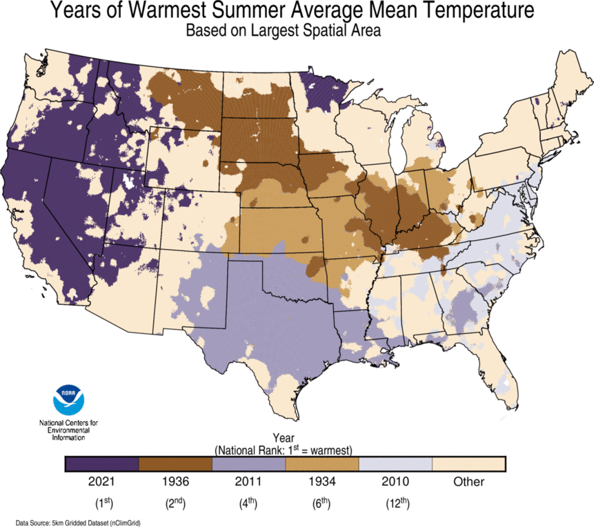
During meteorological summer (June-August), the average temperature for the Lower 48 was 74.0°F, 2.6°F above average, nominally eclipsing the extreme heat of the Dust Bowl in 1936 by nearly 0.01°F and essentially tying 1936 for the warmest summer on record. A record 18.4 percent of the contiguous U.S. experienced record-warm temperatures for this season. For August, the contiguous U.S. average temperature was also 74.0°F, 1.9°F above the 20th-century average and ranked as the 14th-warmest August on record. For the year to date, the contiguous U.S. temperature was 55.6°F, 1.8°F above the 20th-century average, ranking 13th warmest in the January-August record.
The summer precipitation total across the Lower 48 was 9.48 inches, 1.16 inches above average, ranking eighth wettest in the historical record. The August precipitation total for the contiguous U.S. was 3.09 inches, 0.47 inch above average, ranking 14th wettest in the 127-year period of record. The year-to-date precipitation total across the contiguous U.S. was 21.19 inches, 0.48 inch above the long-term average, ranking in the middle third of the January-August record.
Devastating flash flooding and fatalities resulted from multiple events during August including Tropical Storm Fred in western North Carolina, convective flooding from a complex of storms across middle Tennessee, Hurricane Ida across Louisiana and portions of the Northeast in early September and from Tropical Storm Henri, also across parts of the Northeast. With 35 fatalities accounted for during August*, it was the deadliest month for flooding across the U.S. since Hurricane Harvey in 2017.
Wildfires continued to spread across the western U.S. during August as the Dixie Fire in north-central California became the second-largest fire in the state’s history. The Caldor Fire also in California grew rapidly during August, threatening South Lake Tahoe communities. Air quality remained a concern across the U.S. as ash and fine particulates from the many wildfires obscured the skies.
*The remnants of Hurricane Ida impacted the Northeast in early September, raising the 2021 fatality count outside of the August observation period.

This monthly summary from NOAA National Centers for Environmental Information is part of the suite of climate services NOAA provides to government, business, academia and the public to support informed decision-making.
August
Temperature

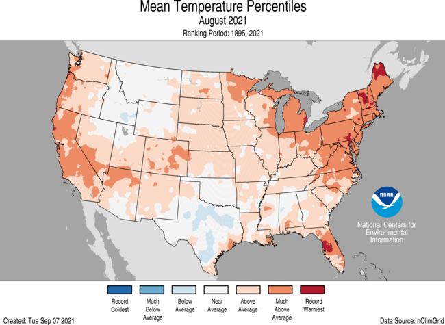
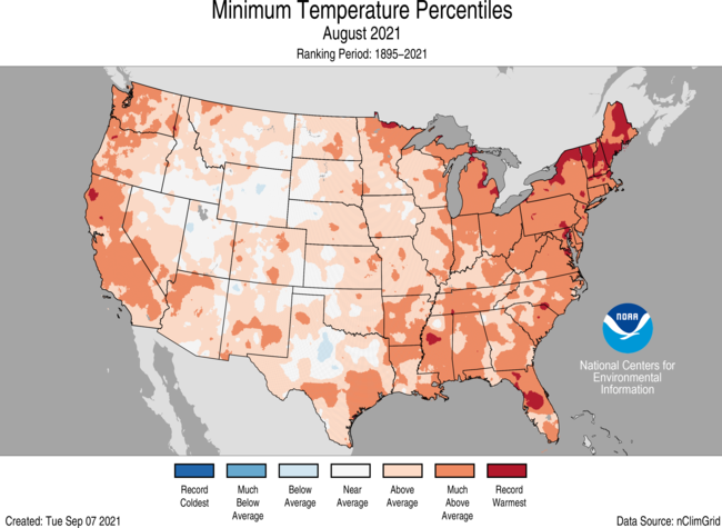
- August temperatures were above average across the West Coast, Southwest and from the Plains to the East Coast. Vermont and New Hampshire both had their warmest August on record while Maine and Massachusetts ranked second warmest. Much of the above-average warmth can be attributed to warm overnight temperatures. Temperatures were near to below average across much of the northern Rockies and the southern Plains.
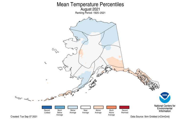
- The Alaska average August temperature was 49.4°F, 0.1°F below the long-term mean, ranking in the middle third of the 97-year period of record for the state. Temperatures were above average across portions of the Southeast Interior, Panhandle and Aleutian regions. Temperatures were cooler than average across the North Slope, Northeast Interior, northern West Coast and parts of Bristol Bay. A persistent cold low-pressure system over the northern Chukchi-Beaufort Seas during August contributed to the cooler-than-average temperatures and the largest observed sea ice extent over the Chukchi Sea since 2006.

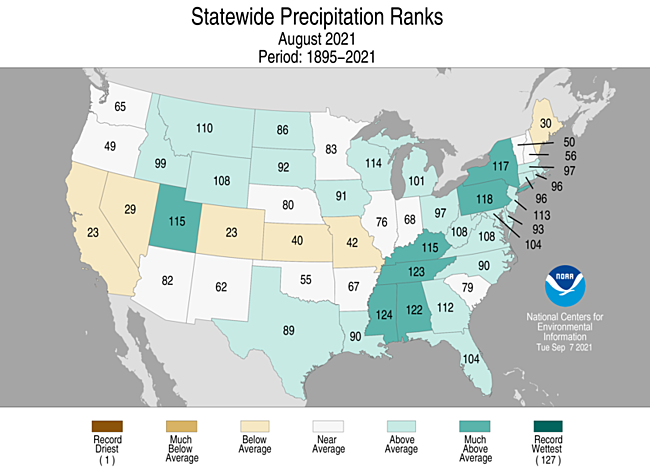
Precipitation

- Precipitation was above average across portions of the central and northern Rockies, the northern Plains, Great Lakes and from the Deep South to southern New England. Mississippi ranked fourth wettest while Tennessee had its fifth-wettest August on record. The Southwest monsoon continued to be active in August, eliminating much of the year-to-date precipitation deficit across the region. Tucson, Arizona, had its wettest August and second-wettest summer on record. Precipitation was below average across portions of the West, southern Rockies, central Plains, Midwest, northern Great Lakes and northern New England.
- Statewide precipitation for Alaska was above average for August, but varied by region. Precipitation was below average across the Aleutians, Bristol Bay and Northwest Gulf regions while the interior regions, Northeast Gulf and Panhandle regions experienced above-average precipitation for the month.
- According to the August 31 U.S. Drought Monitor report, approximately 46.6 percent of the contiguous U.S. was in drought, slightly more than the coverage at the beginning of August. Drought conditions expanded or intensified across the Northern Tier, the Pacific Northwest and portions of California. Drought coverage and/or intensity lessened across parts of the Four Corners region, the Midwest, Hawaii and Puerto Rico and was eliminated in Alaska.
An additional note on Hurricane Ida precipitation and temperature implications: As is typical with very heavy rainfall events, localized bands of very heavy rain may not be completely captured by the gauge-based observing network, which is the basis for this analysis. This circumstance can lead to an underrepresentation of actual rainfall totals. The issue can be compounded by disruptions to the observers' ability to report values during or following a severe event and, in this case, several of our reporting stations posted missing data for both temperature and precipitation during this event. Additionally, quality assurance routines may flag large valid precipitation values as erroneous, resulting in underestimated values. NCEI is working to ensure all reports are indeed validated. As a result, a more complete accounting of the temperature statistics and precipitation across Louisiana during August will be available with the September report.

Summer (June-August)
Temperature

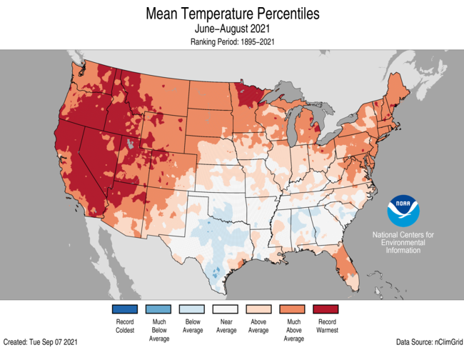
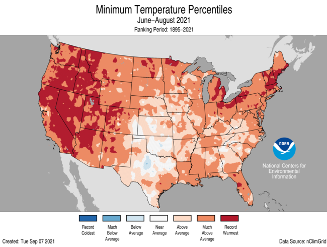
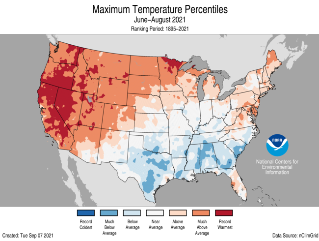
- Summer temperatures were above average to record warmest from the West Coast to the Great Lakes and into the Northeast as well as across portions of the Mid-Atlantic and Gulf Coast. California, Nevada, Utah, Oregon and Idaho each reported their warmest June-August on record. Sixteen additional states had a top-five warmest summer on record. No state ranked below average for the summer season. Temperatures were below average across portions of the southern Plains and Southeast. Warm overnight temperatures heavily influenced the warm summer temperatures, especially across portions of the Southeast, where daytime temperatures were below average for the season.
- The Alaska statewide average temperature for the summer was 51.4°F, 1.0°F above average and ranked in the warmest one-third of the 97-year record. Temperatures were warmer than average across much of the eastern half of the state as well as across the Aleutians and near average for much of the rest of the state.

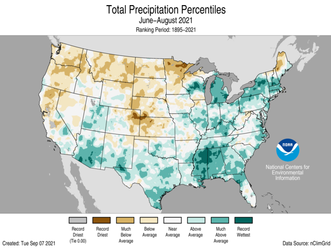
Precipitation

- Precipitation was above average across portions of the Great Basin and Southwest, from the southern Plains to the Great Lakes and across much of the eastern U.S. Mississippi had its wettest summer on record with Alabama, Michigan, New York and Massachusetts ranking among their five wettest summers on record. Precipitation was below average from the Northwest to the western Great Lakes and into the central Plains. Minnesota had its seventh-driest summer on record.
- Precipitation in Alaska was above average across much of the northern half of the state as well as across portions of the Northeast Gulf and Panhandle regions. Precipitation was below average in the southwestern portion of the state. Kotzebue had its wettest summer on record, reporting 9.21 inches and besting the previous record, set in 1963, by nearly an inch. The wildfire season was well-below average with only 254,000 acres consumed — less than half of the median value.

Year-to-date (January-August)
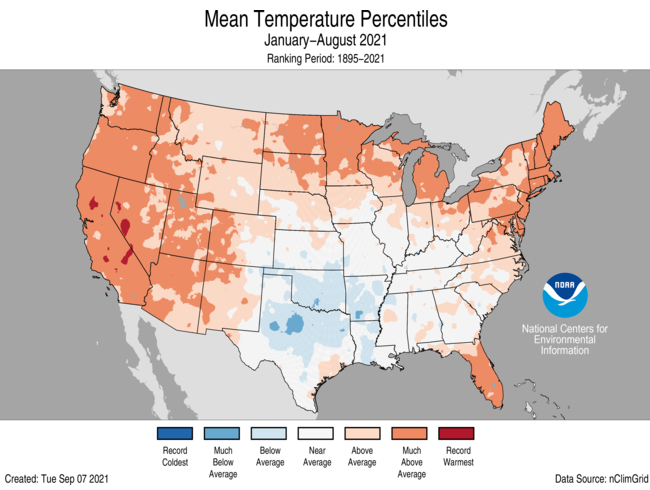
Temperature

- Year-to-date temperatures were above average from the West Coast to the Great Lakes and into the Northeast as well as across parts of the Mid-Atlantic and Southeast. California and Maine each reported their third-warmest January-August on record. Sixteen additional states had a top-ten warmest year-to-date period. Temperatures were below average across much of the southern Plains and lower Mississippi Valley.
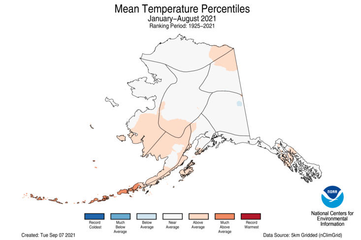
- Year-to-date temperatures across Alaska were near average with above-average temperatures observed across the southwestern portion of the state. Much of the rest of the state experienced near average temperatures for this period.

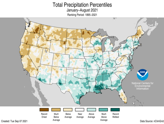
Precipitation

- January-August precipitation was above average from the Deep South to the Midwest, across the Southeast and portions of the Northeast. Mississippi had its third-wettest such year-to-date period on record. Precipitation was below average from the West Coast to the western Great Lakes and across portions of northern New England. Montana ranked fifth driest while three additional states ranked among the driest 10 January-August periods on record.
- For Alaska, January-August precipitation was above average across the West Coast, North Slope and from the Central Interior to the Panhandle. Precipitation was below average in parts of the Cook Inlet region.

For more detailed climate information, check out our comprehensive August 2021 U.S. Climate report scheduled for release on September 14, 2021.


