
Tom Corringham, University of California San Diego
Ask people to name the world’s largest river, and most will probably guess that it’s the Amazon, the Nile or the Mississippi. In fact, some of Earth’s largest rivers are in the sky – and they can produce powerful storms, like the one now soaking California.
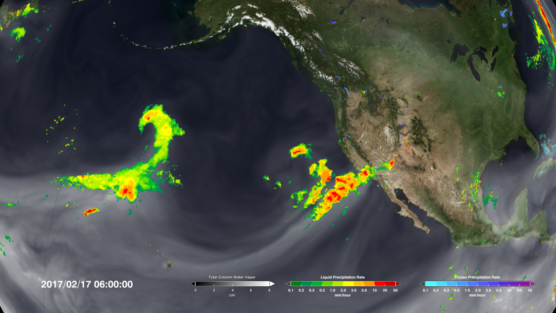
Atmospheric rivers are long, narrow bands of moisture in the atmosphere that extend from the tropics to higher latitudes. These rivers in the sky can transport 15 times the volume of the Mississippi River. When that moisture reaches the coast and moves inland, it rises over the mountains, generating rain and snowfall and sometimes causing extreme flooding.

In the past 20 years, as observation networks have improved, scientists have learned more about these important weather phenomena. Atmospheric rivers occur globally, affecting the west coasts of the world’s major land masses, including Portugal, Western Europe, Chile and South Africa. So-called “Pineapple Express” storms that carry moisture from Hawaii to the U.S. West Coast are just one of their many flavors.
My research combines economics and atmospheric science to measure damage from severe weather events. Recently I led a team of researchers from Scripps Institution of Oceanography and the Army Corps of Engineers in the first systematic analysis of damages from atmospheric rivers due to extreme flooding. We found that while many of these events are benign, the largest of them cause most of the flooding damage in the western U.S. And atmospheric rivers are predicted to grow longer, wetter and wider in a warming climate.
Rivers in the sky
On Feb. 27, 2019, an atmospheric river propelled a plume of water vapor 350 miles wide and 1,600 miles long through the sky from the tropical North Pacific Ocean to the coast of Northern California.
Just north of San Francisco Bay, in Sonoma County’s famed wine country, the storm dumped over 21 inches of rain. The Russian River crested at 45.4 feet – 13.4 feet above flood stage.
For the fifth time in four decades, the town of Guerneville was submerged under the murky brown floodwaters of the lower Russian River. Damages in Sonoma County alone were estimated at over US$100 million.
Events like these have drawn attention in recent years, but atmospheric rivers are not new. They have meandered through the sky for millions of years, transporting water vapor from the equator toward the poles.
In the 1960s meteorologists coined the phrase “Pineapple Express” to describe storm tracks that originated near Hawaii and carried warm water vapor to the coast of North America. By the late 1990s atmospheric scientists had found that over 90% of the world’s moisture from the tropics and subtropics was transported to higher latitudes by similar systems, which they named “atmospheric rivers.”
In dry conditions, atmospheric rivers can replenish water supplies and quench dangerous wildfires. In wet conditions, they can cause damaging floods and debris flows, wreaking havoc on local economies.

Helpful and harmful
Researchers have known for some time that flooding due to atmospheric rivers could cost a lot of money, but until our study no one had quantified these damages. We used a catalog of atmospheric river events compiled by Scripps Institution of Oceanography’s Center for Western Weather and Water Extremes, and matched it to 40 years of flood insurance records and 20 years of National Weather Service damage estimates.
We found that atmospheric rivers caused an average of $1.1 billion in flood damages yearly in the western U.S. More than 80% of all flooding damages in the West in the years we studied were associated with atmospheric rivers. In some areas, such as coastal northern California, these systems caused over 99% of damages.
Our data showed that in an average year, about 40 atmospheric rivers made landfall along the Pacific coast somewhere between Baja California and British Columbia. Most of these events were benign: About half caused no insured losses, and these storms replenished the region’s water supply.
But there were a number of exceptions. We used a recently developed atmospheric river classification scale that ranks the storms from 1 to 5, similar to systems for categorizing hurricanes and tornadoes. There was a clear link between these categories and observed damages.
“
Atmospheric River category 1 (AR1) and AR2 storms caused estimated damages under $1 million. AR4 and AR5 storms caused median damages in the 10s and 100s of millions of dollars respectively. The most damaging AR4s and AR5s generated impacts of over $1 billion per storm. These billion-dollar storms occurred every three to four years.
A moister atmosphere means worse storms
Our most significant finding was an exponential relationship between the intensity of atmospheric rivers and the flood damages they caused. Each increase in the scale from 1 to 5 was associated with a 10-fold increase in damages.
Several recent studies have modeled how atmospheric rivers will change in the coming decades. The mechanism is simple: Greenhouse gases trap heat in the atmosphere, warming the planet. This causes more water to evaporate from oceans and lakes, and increased moisture in the air makes storm systems grow stronger.
Like hurricanes, atmospheric rivers are projected to grow longer, wider and wetter in a warming climate. Our finding that damages increase exponentially with intensity suggests that even modest increases in atmospheric river intensity could lead to significantly larger economic impacts. https://www.youtube.com/embed/X3cP4egWRbk?wmode=transparent&start=0 Scientists have developed a scale for categorizing atmospheric rivers that reflect both their replenishing capacities and their dangerous effects.
Better forecasting is critical
I believe that improving atmospheric forecasting systems should be a priority for adapting to a changing climate. Better understanding of atmospheric rivers’ intensity, duration and landfall locations can provide valuable information to residents and emergency responders.
It also is important to discourage new construction in high-risk areas and help people move to safer locations after major disasters, rather than rebuilding in place.
Finally, our study underlines the need to reduce global greenhouse gas emissions. These storms will keep coming, and they’re getting stronger. In my view, stabilizing the global climate system is the only long-term way to minimize economic damage and risk to vulnerable communities.
[ Deep knowledge, daily. Sign up for The Conversation’s newsletter. ]
Tom Corringham, Postdoctoral Scholar in Climate, Atmospheric Science and Physical Oceanography, University of California San Diego
This article is republished from The Conversation under a Creative Commons license. Read the original article.
I guess 1862 is beyond history for these writers.
https://en.wikipedia.org/wiki/Great_Flood_of_1862
Donner Party, dinner for 50 (1846-47).
AKSTORM!
Wow what a storm!
First time I heard about it.
Claimed 1 in 37,000 year event in San Francisco ???
27 inches n 30 days absolutely huge but not 10 feet.
IMO this highlights that rainfall in a give place can be caused by multiple independent phenomena and theses events are changing with time.
Who would have known – the climate changes.
The 1862 event could have been a common ( once every 200 years) “atmospheric river” storm but is considered a statistical rare “ normal seasonal” storm.
10 feet of equivalent rain is entirely plausible. That’s 100 feet of snow, which has happened, hit by warm rain and converted to floods in a short interval instead of lasting for several months.
Something like that happened in the Winter of 1997 when the snow pack around Bucks Lake was melted by a pineapple express and ran off into Serpentine Canyon of the Feather River, just above Rich Bar. The small village of Beldon a few miles downstream had gravel left 10s of feet above the Summer water level, almost burying a telephone booth. I had commented to a meteorologist I knew that it must have been at least a 1,000-year event. His response was, “No, it was a maximum possible event.”
I would have loved to be able to work those gravels. That was one super hot gold area. I know recreational dredgers who have taken nice sized nuggets from around there prior to that storm.
One Summer, years prior to the flood, I was walking on the smooth bedrock about 20 feet above the Summer water level at Rich Bar. I was thinking to myself, “Now what path would I follow if I were a nugget rolling, sliding, and bouncing on the bottom during flood waters?” I came to a sudden drop-off with a smooth basin; there was a crack in the rock at the upstream edge. I looked at it carefully, and suddenly saw a bit of golden-yellow. I picked at it with my bent crevicing tool, and out dropped a well-rounded, 1/4-oz nugget! I pulled another 1/4-oz of rice-grain size ‘clinkers’ from the same crevice.
In ’97 I was living in Phoenix. Rich Bar was being actively worked at that time. I had made friends with the guy who then owned the claim, but it was quite some time before I was able to get back there. The owner was starting to work upslope near the creek at the boundary with the serpentinite contact, which was probably the source of most of the gold. Much of the gold he was recovering was stained with iron oxide, which reduced its value for use in the jewelry trade. He gave me a nugget to play with. I found that Naval Jelly worked well in removing the iron. In return for the knowledge, he let me keep the nugget, which was also about 1/4-0z.
Rich Bar was the site of the first experimental gold recovery using hardhat diving, in a plunge pool at the mouth of Serpentine Canyon. I once found a 2-oz copper nugget at the base of a very large rock just downstream from the plunge pool. The rock was destroyed by the ’97 flood.
I did my dredging on the Middle Fork of the Feather in the 1980s. My best find was a beautiful 13 pennyweight piece of gold and quartz, which had a triangular shape like a little mountain. I had punched through 12 feet of overburden using a 3″ dredge. Most dredgers stayed away from working that much overburden because of the demands of properly/safely engineering such a deep hole.
It paid off nicely for me though as I found good gold once I got down to bedrock. The bedrock turned out to be shaped like a big bowl in this one spot. In this bowl I eventually uncovered 2 large boulders. The first one I named the Sun as it was almost perfectly rounded and was about 40 inches in diameter. Then just to the east/upstream side of the Sun I gradually uncovered the Moon. The moon was crescent shaped, and about 14 feet long by several feet thick. I could just picture these two large stones beating around the bedrock and forming the bowl in which they sat over time. That was the best gold I ever found in my life getting close to one ounce in one day. Otherwise I averaged 3 pennyweight per day.
I came close to dying underneath the Moon though. The excitement of finding such nice pieces made me a bit careless. I had been able to work underneath the Moon to the point where most of my body was under the rock with only my legs sticking out. I had to use a flashlight to see. I knew that I should have sloped one section of the gravels further for safety on one side of my hole, but the excitement of finding nice gold chips short circuited my inner safety meter. Lucky for me the angel who has always watched over me sent me a warning. As I started working under this rock the next morning I heard someone say “Get out”. The message was so clear that I actually turned my head around in this cave I had fashioned at the time of hearing this. Then I shook my head, and went back to the gold. Then I heard “Get out now”. With that I instantly dropped all of my tools, and backed out of that hole with the speed of a scared crawdad. The entire gravel wall with some large rocks to my left was falling in on me. I had to pop my weight belt as I had around 14 feet of water above me. One sizable rock actually cut into and through my suction hose. My legs had been straddling the suction hose as I worked. that rock would have smashed my legs, and then buried my legs while my body would have been stuck in the cave. That would have been my grave.
Wow! You got lucky there with that one. It is always a good thing to listen to your angel when on your own.
I haven’t had quite the success of you or Clyde but I enjoy gold prospecting as much as anyone. Nothing beats finding the shiny. My biggest piece is just over a gram found up in the Bradshaw’s of Arizona. I love living here.
Thanks Felix
I didn’t know what the equivalent bit meant.
Not sure what this study was based upon but it doesn’t seem like they used any historical data for their research. I have worked in civil engineering in the OC for the last 37 years and got to read several accounts of floods with the ones in the OC flood manual very interesting.
I took a few minutes and found the following articles that explain some of southern California’s historic floods. The rains of March 1983 and in 1995 were intense but nothing like some of the other years listed.
At one time in the late 1990’s the Santa Ana River was the greatest flood risk in the United States and that was fixed (hopefully) by the updating of the Prado Dam and the construction of the Seven Oaks Dam.
https://www.latimes.com/archives/la-xpm-1995-01-15-me-20260-story.html
https://www.pe.com/2010/08/21/santa-ana-river-was-wests-greatest-flood-hazard/
https://www.rsccd.edu/Departments/Risk-Management/Documents/Risk%20Management/IV-C%20Flood-Storm.pdf
https://rcflood.org/About-the-District/District-History
https://ochistorical.blogspot.com/2010/01/flooding-in-orange-county.html
There are many YouTube videos on the 1862 Atmospheric River event for those interested. The linked one, “ARkStorm Movie” is an excellent example. Brief and to the point.
Spot on, John!
Tom Corringham didn’t learn a thing. Instead he’s trying to gin up a tempest in a tea cup using specious sophistry.
If author Corringham had bothered to check the town’s history he wouldn’t make such glaring errors.
Or, at the Sonoma County library:
Tells of floods going much further back than four decades.
Yes, but apparently to these scientists surprise land and building value were not the same.
Previous studies did the same with hurricane damage, and pitiful accounting of inflation.
This is so stupid it defies all description. Has this man never read about the floods of 1862? What were CO2 levels in 1862? You know, 1862. When the great Central Valley of California was a lake more than 450 miles long. When the LA basin flooded beyond anything seen since.
Double face palm doesn’t even begin to cover it.
pbh
.
YAWN !!!
Is that anything like the “Fantastic Four” or the “Magnificent Seven”
Choosing 5 out of a whole bunch of WRONG models is NOT scientific validation.
Whether it’s supercomputer climate simulations or a climate priest throwing some chicken bones in the dirt and “reading” them for future climate divinations, both outputs have about equal predictive sk1ll.
All weather is cyclic. It has happened before, but we in past years we lacked the measurement technology. There is no justification for the claim that anything is getting bigger, longer, more or less extreme (whatever that means), or more or less destructive. However, with respect to the author, it makes a good story and humans cannot get enough to frighten them.
And when we look at weather in recent decades, we see a new, changed pattern driven by warming.
This is obvious in California/western USA, this is obvious in the UK.
The article presents clear evidence for this.
It greatly helps to forget the past in order to accentuate the new.
What you see griff is changed patterns. What you do not see is why the patterns have changed. I don’t either.
That the current pattern is different from last years pattern is beyond question.
However your claim that the current pattern is a new thing, never seen before is easily refuted by just examining the historical record.
One of these days griff will believe something that is actually true.
Alas, today is not to be that day.
Who is we? Don’t you have homework to do?
Actually, Griff, you should check with Dr. Roger Pielke, Jr. before accepting this “study’s” estimation of increasing damage costs. More people and more people’s stuff; pretty soon you have some really big damage figures.
I’ve lived in California for well over 5 decades, and every time we get a wet rainy winter, we’re told by “experts” that this will be the new normal because of climate change. Then when we are in a drought with dry winters, we’re told by “experts” that this will be the new normal because of climate change. Every time anything extreme happens, it’s a new normal. The problem is, I’ve lived here long enough to know that weather patterns in California swing like a pendulum, and that has always been “normal.”
During the winter of 1985-85 I was living in Europe. I relied on the BBC for English-language news. One day Alistair Cooke began his weekly BBC Letters from America monologue with, “As I speak, an area of California the size of England is under at least a foot of water.” Relatives sent me newspaper clippings. My Dad had to sandbag the entrances to the slab-foundation house to keep out the water.
California enjoys five characteristic major weather patterns: Drought, fire, flood, landslide, and earthquake.
Let me get this straight. Global warming will simultaneously cause devastating drought and flood in the same California regions?
California has had quite variable weather as far as records go back, either written or proxy reconstructions. As there was a long drought during the Little Ice Age, any claim of warmer meaning wetter must be discounted.
Using dollar amount damages as a metric for intensity of damages from ARs and then claiming, by inference, that Climate Change is the cause for increases is totally asinine. Roger Pielke, Jr has debunked this kind of junk claims on Atlantic Hurricanes, and the same applies to these major AR events and the damages in dollars.
Junk, junk, and more junk climate pseudoscience.
All of climate science and the tangential disciplines feeding at the grant trough ares now just filled chock-full of unfounded superstition-like beliefs. For the true-believers it means that somehow anything observed that seems unusual to our limited observation periods has got to be attributed anthropogenic CC.
Lomborg lays this out very well
The “expanding bullseye” effect.
More people and infrastructure, not worse storms
The dude who wrote this article has a PhD in economics
Piled higher and Deeper.
More typical ridiculous fear-mongering. Nothing more than that.
“It never rains in California, but girl, don’t they warn ya?
It pours, man, it pours”
great song.
Southern California?
I thought “God didn’t make little green apples
And it don’t rain in Indianapolis in the summertime”
Scientific American in 2013 https://www.scientificamerican.com/article/atmospheric-rivers-california-megaflood-lessons-from-forgotten-catastrophe/ and Wired Aug. 2020 https://www.wired.com/story/the-biblical-flood-that-will-drown-california/
What a coincidence! Last weekend we had an atmospheric river in Chile that meant 35 mm precipitation in 24 hours over Santiago alone, something not seen since 1950. Blaming man-made climate change for one single event in 71 years is a bit too much, besides statistically absurd. Details in: http://floodlist.com/america/chile-floods-storm-january-2021
35 mm is about 1 1/2 inches. ?????
Terrain and soils matter.
For those who live among gently sloping hills of absorbent soils, 1 1/2 inches of rain in 24 hours is a nuisance. If you live at the base of near-impermeable granite mountains at the convergence of mountain gullies floored with clay soils that absorb water only very slowly then 1 1/2 inches of rain in 24 hours is a disaster.
View the photos of Santiago at the link Dennis Pollock provided.
In the NW the weather announcers call it the ‘Pineapple Express’ when it originates in the Pacific N of Hawaii. It has ALWAYS been there and it moves up and down the coast in a random fashion. It is weather, not climate! The author has NO basis for determining it has not happened over the centuries and therefore is caused by, or results from so called ‘climate change’.
The weatherguessers USED TO call them the “Pineapple Express”, storms that brought heavy rainfalls to California. A few years ago, the radio “news” was talking about the extreme drought, and how California needed 12 TRILLION gallons to get back to normal. Two DAYS later, an “atmospheric river” inbound to central California was estimated to contain 13 TRILLION gallons of water.
If only the useless California politicians had done something – ANYTHING – to build water storage facilities over the past 30 years (which they have NOT done), then that water, or some of it, could have been captured and stored. But CA politicians don’t to “solve” that problem; they just want to complain.
Matthew 7:7-8
“They just complain”.
I wish that was all.
They are ‘here to help” dang it.
California has “buil(t) water storage facilities over the past 30 years”. Also the capacity of existing facilities has been increased. You can look it up.
Trouble is, by 50 years ago (the 1970s) all the best and easiest places to build water storage dams had already been dammed. Also, California’s dams are engineered and operated to perform at least two seemingly contradictory functions: water storage and flood control. To maximize water storage, one would keep reservoirs behind dams filled to their design maximum. For flood control, one would keep those reservoirs empty in order to buffer as much flood water as possible.
Beyond dams, California also has innovative flood water diversion and retention facilities such as the Yolo Bypass and Sutter Bypass. The era of cheap dam building is long over; development of more sophisticated flood water diversion and retention systems has been underway for the past 30 years, especially in Southern California’s coastal counties. For example, the making of the Los Angeles River into a concrete-lined sluiceway to the Pacific by the flood control managers of a century ago is now regarded as a great mistake. It is now being slowly remodeled into a more naturalistic river that will one day meander through a complex of lagoons, lakes, and waterways that can capture, hold, and clean floodwaters while serving as refuges for migratory birds, groundwater recharge, recreational facilities, and community scenic amenities. This is occurring little by little as properties along and near the Los Angeles river are redeveloped and repurposed. This rectification of 20th century gung-ho quick and dirty waterway engineering is expensive and not expected to be completed until the 22nd century.
People who make off the cuff cracks about California lacking dams simply do not know what they are yammering on about. Why are the people most ignorant about California the people who are most critical of California?
Enough
Pick a region
Come up with a hypothesis ( more rain or less)
Carry out a detailed analysis of multiple catchments within the region.
If theses detailed assessments don’t agree then reject the hypothesis.
I am yet to see a valid quantitative analysis at catchment levels that validates ipcc regional projections. Thus the ipcc are wrong.
The smarter ones have files labelled – hotter, dryer, wetter, colder, more snow, less snow, more intense cyclones, fewer cyclones and so on. Whenever there is a weather event they look up the appropriate file and publish the most appropriate paper to coincide with the event. That guarantees it gets attention.
The fact that Earth’s temperature is fundamentally stuck where it is now for at least the next millennia garners zero news interest.
A great deal of pop media can be understood as Panic the Females teasers and clickbait. Females control 85% of consumer spending (at all levels, from household necessities to luxury goods). Grabbing the eyeballs of panicked females is easy and selling those eyeballs in bulk to advertisers is very very profitable.
What is it about the Climate Catastrophists that they take such pride in their ignorance of history?
This denial of recorded history is a constant feature of the CAGW moaners.
The Cult of Calamitous Climate,requires their members to be willfully ignorant of past events?
Cause it takes a special kind of ignorance to state a weather event as “Unprecedented” (since 1862)
..
Anyone of knowledge repeating drivel like this deserves to be unemployed. Where are fact checkers when they are needed?
Exactly! They keep repeating the same empirically falsified load of bollox ad infinitum and always come up short when asked for any evidence.
In fact nothing could be further from the truth. The energy in storms arises from temperature differentials, a condition that has been diminishing as global temperatures rise. This is easily verified by noting the ~ 95% drop in storm damage, globally, since the turn of the 19th century.
I just know someone will jump all over me for saying this, but: this planet doesn’t have a climate so “it” certainly can’t be altered by human influence. It’s like blaming humans for the extinction of unicorns. Considering that change is the default condition of this planet’s atmosphere, the term “climate change” is just an appeal to ambiguity and a pointless tautology. Averaging weather at a single location is vague enough, but averaging hundreds of locations on a global scale is just plain nonsense. I don’t know of a single “climate” on the planet showing measurable change, let alone caused by humans.
Unicorns are extinct!
Where will all the farts come from?
Like anthropogenic CO2, unicorn farts accumulate and last forever, while amplifying their own effect indefinitely. The only difference is; unicorn farts are the panacea for all evil and the source of true happiness.
Unicorns aren’t extinct, they are just very good at hiding.
“Dr. Tom Corringham joined the Center For Western Weather and Water Extremes as a Post-Doctoral Scholar in July of 2018 after completing his PhD in Economics at the University of California San Diego, under advisors Richard Carson and Dan Cayan.”
Somebody gave this fellow a PhD. Someone who never read of the 1862 flood (or deliberately ignored it), and someone who doesn’t know of the tree trunks way below present water level in Sierra Nevada lakes, feels because of that degree that he is qualified to write this stuff–and worse, that someone should listen.
We have a problem.
It was most gratifying to see every point that came up in my mind when reading, already here in comments by the time I got around to reading the article. There is however light on the horizon–the coming Covid-generated New Great Depression (Rickards) will likely soon reduce Mr. Corringham to his real value in society.
The Human Animal eh, what is it like?
Raving about One Thing while, utterly lacking in self-awareness, giving away its actaul concern/worry. And this one is beautiful.
Let’s unpick it…
Quote:
“”Just north of San Francisco Bay, in Sonoma County’s famed wine country, the storm dumped over 21 inches of rain. The Russian River crested at 45.4 feet – 13.4 feet above flood stage.
For the fifth time in four decades, the town of Guerneville was submerged under the murky brown floodwaters of the lower Russian River. Damages in Sonoma County alone were estimated at over US$100 million”
Basically, they are concerned about wine and money
Using Big Numbers to clearly demonstrate the depth (haha) of that concern.
Also their own Muddled Muppetry,
Puhleeze people, recording Feet & Inches down to one decimal, decimal place?
Never mind that, what we do see here by the bucketful is:
all in one in just the photo they thesmselves present, to try demonstrate something which they themselves say, have been going on Since Forever.
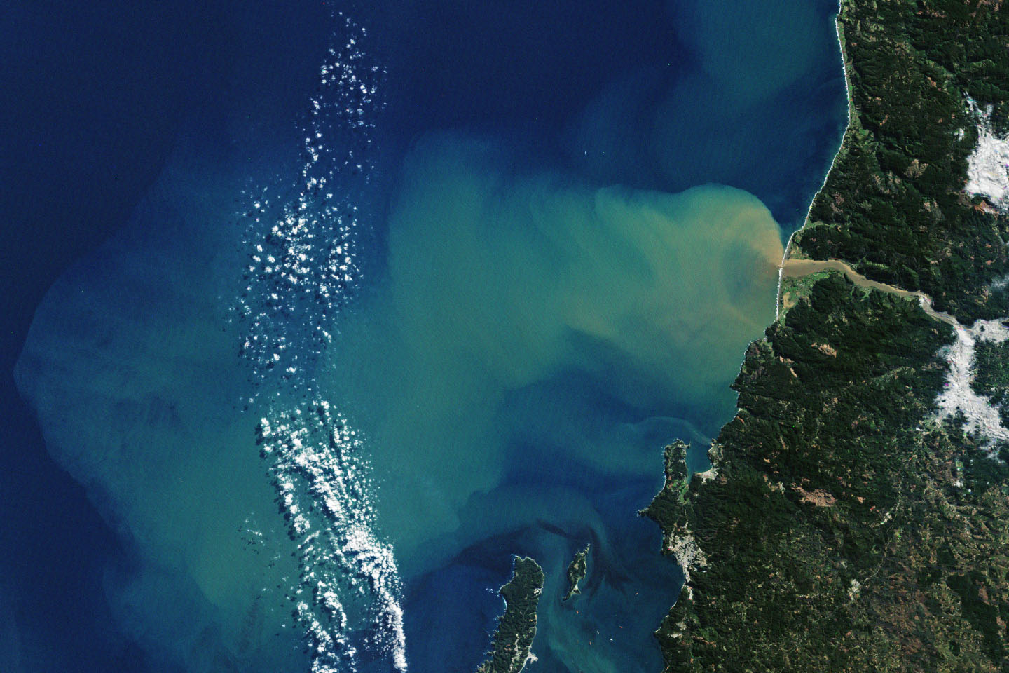
Thus we’re presented the pic we see of The Chile Coastline
(Same photo, mine must be where they lifted it from)
See that muddy brown water coming out of the river?
That (muddy) water is carrying away, never to return, your physical & mental health, your entire life & longevity. It is carrying away your children & grandchildren.
That mud is you, me, everyone and All Life On Earth
No, muddy river water is NOT natural and NO, it is NOT caused by Atmospheric Rivers
It is Soil Erosion, created by me and you, in our pursuit of cheap, nasty, tasteless and low nutrient (nutrient free in fact) food.
And the low nutritional status food gets ever and ever lower because that mud IS or was, its nutrient content of the soil/dirt the food was/is being grown on.
That wine actually counts as food is bad enough, but, as you know from me, the wine and sugar is what’s causing the (bullet pointed) list above.
And that mud, or its disappearance from where it should be, is what’s causing the Observed Climate Change.
So perfectly circular, so perfectly wrong. Gotta give credit for that.
sigh
Whaddya reckon Monckton, is that One Hell Of A Feedback System – a Positive Feedback System to boot and:
‘Hell’ is precisely where all Positive Feeders finish up, taking with them all the critters that hitch a ride on their backs.
Nice (perfectly vacant, empty, thoughtless and non) work.
Thank you Climate Science. Thank you so much. So much Nothing. So much junk. So much selfishness. So many big numbers (& willies)
So much Wasted Everything
I’m getting the impression that you actually believe that soil erosion is a new thing.
Soil erosion has existed for all time. It’s what created the world’s great river deltas long before humans had any influence on the planet. Poor farming practices increase erosion locally but, by no means, created it. Food is obviously not nutrient-free, if it was, all animal life would perish starting with the herbivores. You should move on, your wacky “soil erosion causes climate change” thesis has no merit.
Yes. The billions of dollars lost due to crop damage by insects is proof that today’s farmers are not producing nutrient-free food.
Crop pests haven’t been starved into extinction yet & never will be.
Patrick Michaels said that warming is accentuated at the poles so there is a smaller difference between the temperature at the poles and the temperature at the equator. Strong storms and winds are caused by this temperature difference so there will be fewer strong storms and winds in a warming world. I think the accentuated warming at the poles is due to the difference in heat capacity of cold dry air and warm moist air.
Looking at data that goes back at most 40 years is hardly adequate to say anything at all about climate change. Tom Corringham, I dispare for the state of post graduate science, based on your example.
I grew up in the SF Bay Area in the 50’s & 60’s and lived in the East Bay until 1/1/2013. The author of the study implies that large storms are increasing in flood damage. The problem with this is they limited their time period to 40 years missing the 1950’s & 1960’s. Until the late 60’s the Russian River flooded Guerneville every year*. Very little flood control has been added to the Russian River & tributaries since then to account for the lower frequency of flooding. There are two dams that were added in the 1970’s & 1980’s, one a dual use & one for water storage for Marin Municipal Water District. The water storage reservoir was built in response to the late 70’s drought that required taking one lane of the Richmond San Rafael bridge to run a large pipe that carried water from the EBMUD system to the MMWD system.
Note: there are many streams that feed the Russian River between Lake Mendocino which is just north of Ukaih & only one has has a dam on it that forms Lake Sonoma.
P.S. Northern CA had floods on many rivers almost every year in the 50’s & early 60’s. The frequent flooding was solved by damming many rivers & building the Yolo Bypass that in high flow periods bypasses the excess flow by opening flood gates above Sacramento flooding a lot of.farmland. All the structures in the flood plan are above the high water mark.
We are around the same age. I also remember all of that, and the almost annual flooding of Guerneville and the Russian River through the 50s/60s. Guerneville was very popular back then for summer camping.
This 65 yo native Californian has witnessed the Russian River flooding 30 or more times since 1955. All the way back when the chrome was thick and CA’s population was a fraction of what it is today
https://www.mercurynews.com/2019/03/04/why-does-guerneville-flood-so-much-and-why-cant-it-be-fixed/
Atmospheric River? Or inadequate flood management for lack of man made dams?
Global Warming hysteria has nothing whatsoever to do with it
He was doing OK up to the point he introduced the now mandated, blame the humans for everything paragraph.
Quote.
“Finally, our study underlines the need to reduce global greenhouse gas emissions. These storms will keep coming, and they’re getting stronger. In my view, stabilizing the global climate system is the only long-term way to minimize economic damage and risk to vulnerable communities”.
Why do supposedly intelligent people do this?
“Why do supposedly intelligent people do this?”
Because clever people are so driven to favor complicated answers so much that they’ll fool themselves into seeing all problems as something so complicated that only clever people can fix them?
As clear a set of evidence as you could wish for to show climate change affecting western USA.
The ‘its just weather’ and ‘all this has happened before’ arguments don’t stand in the face of evidence of the change to current conditions.
Once again, griff proclaims that any weather that is different from last year’s is proof of global warming.
BTW, not only has rain like this happened before, rain much worse has happened before.
Apparently you’re still having problems working out what climate is and why the two terms are not interchangeable. Aside from that, the burden of proof is on you to provide empirical evidence that humans are the cause.
I get the distinct impression you’re suggesting that climate was static in the past.
The author provides no basis for asserting “storms are getting stronger.” Looking back at least 70 years would be advisable, considering the obvious multidecadal sinewave type records.
“Over the past ten years the company Aquiess has repeatedly demonstrated this technology to government and humanitarian observer groups. The proprietary weather modification system operates by utilizing ‘resonance’ signals to divert oceanic atmospheric-rivers (OAR) into areas experiencing severe drought. The Aquiess system does not rely on chemical or biologically hazardous materials, which could potentially harm the environment.”
Aquiess and Sci-Blue Steer Atmospheric River Over Texas · Weather Modification History
I might have missed it, but where is his evidence that any of this is any worse than before?
Any definition of “worse” that relies on the amount of property damage is not based on the objective severity of weather phenomenon.
I often have a difficulty with rating some articles: 5 stars for showing them, but 0 stars for the contents. Is that a 2?
More manure from The Miserable Conversation. The greatest AR which hit the US West Coast in my 70 years of life struck in the winter of 1964/65. The second strongest AR was probably a tie between 1955/56 and 1996/97. The greatest known West Coast AR of all time was in the winter of 1862/63. The very strong AR of 2016/17 was powerful, but it was more localized than any of the other above examples.
I find it hard to comprehend how these supposed scientists can be so blind to reality, and so arrogant to think that they are superior minds.
Until Atlantic Americans arrived in California and began building levees and later, dams, for much of the year Native Americans crossed California’s Great Central Valley by canoe.
History, it’s more than just dusty old unread books written by dead white men.™ More people should read those books and learn some history.
P.S. Why do feminists consider the word ‘history’ sexist but not the word ‘<u>her</u?itage’? I’m asking for a buddy taking a Grievance Studies course at a California state university.
Until Atlantic Americans arrived in California and began building levees and later, dams, for much of the year Native Americans crossed California’s Great Central Valley by canoe.
History, it’s more than just dusty old unread books written by dead white men.™ More people should read those books and learn some history.
P.S. Why do feminists consider the word ‘history’ sexist but not the word ‘<u>her</u>itage’? I’m asking for a buddy taking a Grievance Studies course at a California state university.
Until Atlantic Americans arrived in California and began building levees and later, dams, for much of the year Native Americans crossed California’s Great Central Valley by canoe.
History, it’s more than just dusty old unread books written by dead white men.™ More people should read those books and learn some history.
P.S. Why do feminists consider the word ‘history’ sexist but not the word ‘HERitage’? I’m asking for a buddy taking a Grievance Studies course at a California state university.
The age of current events climatology is upon us.
The definition of the word “river” is seriously being mauled. If any flow of water by some physical process within the fluids that govern the Earth’s climate can be called rivers, then probably the Western Atlantic Gulf Stream is the largest river in the world. But I do not hold by such tripe. The Gulf Stream is NOT a river, it is an ocean current. So-called atmospheric rivers are not rivers in the same sense as surface rivers, because they have no stream beds, no flood plains, no alluvial fans when the hit the boundary of land to ocean. What they are is a phenomenon not well understood until very recently, when satellite weather tracking showed us their extent and power. And just like the horrid example of the so-called “ozone hole” over the Antarctic continent, which was turned into a human caused disaster almost from it’s very inception (which was not when Dobson measured low ozone levels from the beginning of his experiments on that continent in the 1950s, but rather when the first remote sensing missions looked down upon it from space in the early 1970s), we simply do not have enough history with so-called atmospheric rivers to say we know “JACK SQUAT” about whether they are increasing, decreasing, trending this way or that, or about what the significance of any trends might really mean in the long run. Did so-called atmospheric rivers push huge amounts of water onto the land during periods of glaciation? I would bet they did. How could those glaciers form and carve out the valleys that we see today that are U-shaped, but have no glacier in them, anymore, one of which is Puget Sound? How could water have filled the Great Basin to overflowing in Lake Bonneville (now a tiny little endorheic runt called Great Salt Lake). What water source filled Lake Missoula and carved the Columbia and Snake River gorges with great floods we could not even imagine until recently. How could almost the entire area of what is now Canada and the northern states of the USA been covered in a mile or two of ice? Seriously, was there no atmospheric river involved? Was that just a friendly little atmospheric babbling brook, before human CO2 began to turn it into a raging monster? This idiocy must stop!
Ps. For the best use of the phrase “we don’t know JACK SQUAT” refer to climate gate e-mail from Ed Cook. Oh, wait, he used another term. My favorite use of the term in all of human history is Chris Farley as motivational speaker Matt Foley on an SNL sketch. If only I could figure out a way to defund climate alarmists, and see them all living in a van down by the river, eating a steady diet of government cheese. https://www.youtube.com/watch?v=Xv2VIEY9-A8
Courtesy, Merriam Webster:
Your personal opinion regarding the definition of “river” is narrow, Mickey Reno.
But Jerry Brown was too focused on Antarctic ice to worry about his home state. Money does that to politicians.
Er…
I don’t thing the word “focused” belongs in the same sentence as “Jerry Brown”.
Hmmm. “By the late 1990s atmospheric scientists had found that over 90% of the world’s moisture from the tropics and subtropics was transported to higher latitudes by similar systems, “
Sounds like evaporating moisture in the tropics (absorbs heat) moves to cooler areas and drops (condenses and gives up heat). Who would have thunk it? Heat moves from warm to cool areas? Perish the thought.
Dr. Corringham reports that higher surface temperature makes for more evaporation and more water vapor in the atmosphere leading to stronger storms. That has a right kind of feel to it but If so, then atmospheric humidity, relative and specific, and total column water vapor must be increasing for the past many decades. These kinds of parameters are routinely measured and the measured data by NOAA does not agree.
NOAA says that relative atmospheric humidity has going down at all altitudes measured including near the surface (1,000 mb) since 1948. Specific humidity has also been going down at altitude, while near the surface it’s up a wee bit. Also, total column water vapor has declined or remained unchanged since 1983. See for yourself at climate4you.com under the climate+clouds button.
I find it curious that Dr. Corringham would not consider readily available atmospheric water vapor data before making his alarming conclusions. It is equally curious that he apparently did not consider economic development in the affected areas before concluding that increasing damage is caused by worsening storms. Perhaps Roger Pielke needs to review the paper?
According to the data provided by the alarmists, the oceans have warmed by about .06C. I wonder how much extra evaporation that would cause?
Beyond that, evaporation of water takes energy. If there is a huge increase in evaporation as the alarmists claim, this means that there has been a huge cooling in the tropics. Evaporation is a large negative feedback that none of the models take account of.
I do not have much knowledge of what the world’s climate models do or don’t consider. If you have such information, please post it here. Removal of heat from the surface of the earth by evaporation must be a major heats-loss mechanism. Willis Eschenbach has written about it on several occasions. It certainly is apparent on my sweaty summer forehead. The now wetter warm air rises (warm humid air is lighter than warm less-humid air), forms clouds at some altitude releasing the heat of evaporation with half going up and mostly out to space and half going down. Perhaps models try to parameterize this process because it occurs over much smaller areas than the areas considered by models. If they do not consider it at all, it seems to me that that is a major perhaps fatal failing.
Under the topic of helpful and harmful they mention only harmful. It seems to me that the nutrients sent to the sea in floods help fertilize the ocean, and also help move organic and inorganic carbon to direct and rapid burial — i.e. a carbon sequestration method.
If one wishes to avoid most of the harm, stop subsidizing building in flood plains.
Very sensible discussion up to the point where the word prediction is introduced. Once we get to projecting what atmospheric rivers will do in a slightly warmer world, we begin gazing into a totally unreliable crystal ball. We move from objective evidence to conjecture based on only a scanty few known facts and a whole lot of assumptions.
I grew up in the Bay Area and I remember Guerneville flooding all the time and I wondered why anyone would build a house there. Still people have homes there right on the river. I don’t know the impact, but there’s been a lot of paving over of Ca in the last 50 years. It has to increase the danger of flooding.
Is it even conclusive that atmospheric moisture has trended upward? Never mind AGW.
I just want an honest science answer to the moisture question.
When I google images – “atmospheric moisture trend” I get a whole lot of contradiction like this.
It was just a few years ago that the California drought was permanent because of global warming.
Yes, its ‘Brown California’ as Mann says so, he claims its not just ‘dry’ but ‘hot’ as well which together spell ‘doom’
https://www.pnas.org/content/112/13/3858
In December of 1964, when college Christmas Break started, it started raining in Northern California. My recollection is that it rained non-stop for about 2 weeks. Just before Christmas, the rock-fill Hell Hole dam under construction on the Rubicon river failed, and the reservoir water poured into the Middle-Fork of the American River, taking out something like 13 suspension bridges on the way down; the first bridge to survive the wave of water was the railroad bridge just outside of Auburn. Catastrophic floods in California are not a new phenomena.
The 1964 flooding wasn’t confined to California:
https://en.wikipedia.org/wiki/Christmas_flood_of_1964
That flood struck the entire coast all the way up into Canada. I took a Greyhound bus ride from SF to Seattle in the summer of 1965 to stay with my cousins. I had never seen such extensive damage in my life. What was supposed to be an 18 hour bus ride ended up taking 38 hours because of all of the many road detours. There were improvised bridges over streams in places, washed out roads everywhere, and people working at straightening all of this mess out all the way along the trip.
It was estimated that around 4,000 vehicles were swept down the length of the Klamath river and out into the ocean. Every bridge across the mighty Klamath river went down with the exception of the bridge at the ancient Indian town of Weitchpec. That bridge crosses a deep gorge over the Klamath right above where the Trinity river joins the Klamath. The bridge sits high above the river, maybe close to two hundred feet. When I was living there in the 1970s you could still see tree branches stuck in the girders of the bridge. That was why this bridge survived, but only barely. When you stand on that bridge and look to the west at the wide junction where the two rivers joined it is almost incomprehensible to imagine that vast area filled with raging mud filled water. An interesting note to this area is that the old ancient town of Weitchpec which sat on a bar just to the south of this bridge was estimated to be around 15,000 years old. The 1964 flood wiped out that ancient site, and left only a long sand/gravel bar in its wake.
Thanks for that
https://en.wikipedia.org/wiki/Christmas_flood_of_1964
‘California Governor Pat Brown was quoted as saying that a flood of similar proportions could “happen only once in 1,000 years,”
That flood was probably very close to the level of rain which struck during the Ark Storm of 1862/62. The saving grace for the Sacramento Valley was that the dam on the Feather River at Oroville had just been completed, and was ready to be filled in the winter of 1964/65. It was estimated that the dam would be filled by the end of the 1960s. However, the huge rains in that winter filled the dam in one fell swoop. That saved the upper Sacramento Valley and all the way down the Sacramento river from being completely inundated.
Yes, the Summer of ’65 was a difficult time to get around in Trinity Co because of all the temporary bridges.
But the so called greenhouse gases do not trap heat energy. Good absorbers are also good radiators. What ever LWIR photons they absorb they quickly radiate away for a net heat energy gain of zero. The greenhouse gas molecules also sharre heat energy with surrounding gas molecules just like all molecules in our atmosphere. If any molecules are heat trapping it would be the non-greenhouse gas molecules because they are such poor radiators to space.
It is my experiencing from living on the cost of California for more than 60 years, storms decades ago seem to have been a lot worse than the storms we have had this year.
There is one other factor of great interest to consider when talking about West Coast flood patterns. Note how close to the solar minimum these largest storms are. The 1964/65 major flood which inundated everything from Marin county north to the Canadian border struck right at the solar minimum as did the major ARs of 1955/56 and 1996/97. The localized large AR in 2016/17 occurs right as this last solar minimum begins, note that sunspots zeroed out right at the very end of Dec 2016.
There is a statue of the Donner Party at that lake which represents the depth of the snow which trapped them. I was living at Lake Tahoe in the winter of 1970/71. The snow that year equaled the depth of the snow that the Donner Party encountered as it rose to the exact same height as the memorial statue at Donner Lake. There was an amazing 12 feet in 3 days in late December after many earlier strong snow storms, and then around 10 days later we were hit with 6 feet in one day. I finally dug my car out of the snow in late April 1971.The odd thing about this is that there are no records of this huge storm. They have been lost to time for some reason.
There is a possible correlation between that snow in 1970/71 and the Donner Party tragedy in that sunspots were at low levels. The Ark Storm of 1862/63 is also similarly situated, striking not long after a rapid drop from the max of that cycle.
Everyone fails to realize that after 4 billion years the climate was perfect in 1950. March, actually. March, 1950. Yup, we had it and blew it.
“Like hurricanes, atmospheric rivers are projected to grow longer, wider and wetter in a warming climate”. Except that they haven’t. I don’t know about you, but I’m really getting tired of this alarmist BS. It seems to never end and to be getting more desperate.
Seems there’s some confusion about atmospheric greenhouse rivers.
Warm brown greenhouse pissing https://youtu.be/QkuSKTcxDfk
related: Jobs in greenhouses https://www.google.com/search?q=greenhouse+workers+in+poland&oq=greenhouse+workers%7C&aqs=chrome.
https://www.google.com/search?client=ms-android-huawei&sxsrf=ALeKk01fzu-TCKJT0qlnxjAfyRbAmOiRLA%3A1613193985779&ei=AWMnYJ6CL5L4gQb9uYuIAQ&q=greenhouse+workers&oq=greenhouse+workers&gs_lcp=ChNtb2JpbGUtZ3dzLXdpei1zZXJwEAMyBAgjECcyBAgjECcyBAgjECcyAggAMgIIADICCAAyBggAEBYQHjIGCAAQFhAeUI6EAliBigJgkLMCaABwAHgAgAGQAYgBowOSAQMwLjOYAQCgAQHAAQE&sclient=mobile-gws-wiz-serp
Anyway, ~cr : rule of thumb:
CO₂ lags temperature –
– First heat the Greenhouse, add CO₂
– Then plants grow !