

Climate: The climate is generally hot and humid. There are two distinctive seasons: the rainy season, from May to November, and the dry season, from December to April. The annual average temperature is 270C. The hottest month is April and the lowest is December. It is warm all year.
Area: 2,095.5 sq. km
Population: 7,396.5 thousand habitants (2010)
Administrative divisions:
Districts: District 1, District 2, District 3, District 4, District 5, District 6, District 7, District 8, District 9, District 10, District 11, District 12, Tan Binh, Binh Thanh, Phu Nhuan, Thu Duc, Go Vap, Binh Tan,Tan Phu.
Rural districts: Nha Be, Can Gio Hoc Mon, Cu Chi Binh Chanh.
Ethnic groups: Viet (Kinh), Hoa, Khmer, Cham...
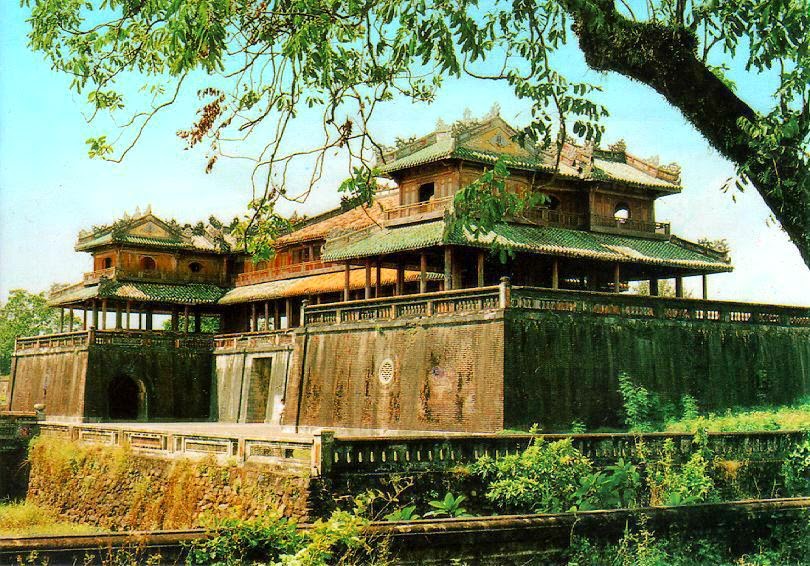
Despite its quite recent past, Sai Gon City nevertheless possesses various beautiful buildings, displaying a characteristic combination of Vietnamese, Chinese and European cultures. These include Nha Rong (Dragon House Wharf), Quoc To Temple (National Ancestors Temple), Xa Tay (Municipal Office), Sai Gon Municipal Theatre as well as many pagodas and churches (Vinh Nghiem, Giac Vien, Giac Lam, Phung Son pagodas...). After more than 300 years of development, Sai Gon City presents many ancient architectural constructions, famous vestiges and renowned sights. It is remarkable for its harmonious blending of traditional national values with northern and western cultural features.
- Roads: Sai Gon City is 1,730km from Hanoi, 99km from Tay Ninh, 30km from Bien Hoa (Dong Nai), 70km from My Tho, 125km from Vung Tau, 168km from Can Tho, 308km from Dalat, and 375km from Buon Ma Thuot. The City has National Highway 13 which connects Vietnam with the rest of Indochina.
- Train: Thong Nhat express train connects Sai Gon City and Hanoi, vie many provinces in Vietnam.- Air: Tan Son Nhat International Airport, 7km from center of city, is the biggest airport with many domestic and international routes. There are flights from Hanoi and Danang to Sai Gon City and between the City to many regions as well a lot of countries on over the world.
Area: 2,095.5 sq. km
Population: 7,396.5 thousand habitants (2010)
Administrative divisions:
Districts: District 1, District 2, District 3, District 4, District 5, District 6, District 7, District 8, District 9, District 10, District 11, District 12, Tan Binh, Binh Thanh, Phu Nhuan, Thu Duc, Go Vap, Binh Tan,Tan Phu.
Rural districts: Nha Be, Can Gio Hoc Mon, Cu Chi Binh Chanh.
Ethnic groups: Viet (Kinh), Hoa, Khmer, Cham...
History
Many centuries ago, Saigon was already a busy commercial center. Merchants from China, Japan and many European countries would sail upstream the Saigon River to reach the islet of Pho, a trading center. In the year of 1874, Cho Lon merged with Saigon, forming the largest city in the Indochina. It had been many times celebrated as the Pearl of the Far East. After the reunification of the country, the 6th National Assembly in its meeting of the 2nd of July, 1976, has officially rebaptized Saigon, Sai Gon City. The history of city relates closely with the struggle for the independence and freedom of Vietnam.Tourism
Today, Sai Gon City is the big tourism center in Vietnam, attracting a large of visitors to Vietnam. Sai Gon City has various attractions as Sai Gon Museum, formerly known as Dragon House Wharf, Cu Chi Tunnels, system of museums, theatres, cultural houses... Recently, many tourist areas are invested such as Thanh Da, Binh Quoi Village, Dam Sen Park, Saigon Water Park, Suoi Tien, Ky Hoa..., which draw numerous tourists.Despite its quite recent past, Sai Gon City nevertheless possesses various beautiful buildings, displaying a characteristic combination of Vietnamese, Chinese and European cultures. These include Nha Rong (Dragon House Wharf), Quoc To Temple (National Ancestors Temple), Xa Tay (Municipal Office), Sai Gon Municipal Theatre as well as many pagodas and churches (Vinh Nghiem, Giac Vien, Giac Lam, Phung Son pagodas...). After more than 300 years of development, Sai Gon City presents many ancient architectural constructions, famous vestiges and renowned sights. It is remarkable for its harmonious blending of traditional national values with northern and western cultural features.
Transportation
Sai Gon City is the main junction for trains, roads, water, and air transportation systems for domestic trips and for foreign destination.- Roads: Sai Gon City is 1,730km from Hanoi, 99km from Tay Ninh, 30km from Bien Hoa (Dong Nai), 70km from My Tho, 125km from Vung Tau, 168km from Can Tho, 308km from Dalat, and 375km from Buon Ma Thuot. The City has National Highway 13 which connects Vietnam with the rest of Indochina.
- Train: Thong Nhat express train connects Sai Gon City and Hanoi, vie many provinces in Vietnam.- Air: Tan Son Nhat International Airport, 7km from center of city, is the biggest airport with many domestic and international routes. There are flights from Hanoi and Danang to Sai Gon City and between the City to many regions as well a lot of countries on over the world.


