At a Glance
- A system resembling a subtropical storm may form in the Mediterranean Sea late this week.
- Flooding has already impacted parts of Greece, and additional rainfall is expected through late week.
- These systems have developed in the Mediterranean before, including around Halloween 2016.
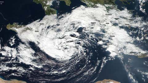
A Mediterranean Sea low-pressure system may develop into a "medicane", a nickname for systems in this area that gain some characteristics of Atlantic subtropical or even tropical cyclones, and may deliver more flooding rain to already flood-ravaged parts of Greece.
This area of low pressure, named Numa by the Free University of Berlin, is currently in the Mediterranean Sea southeast of Italy and will track east into Greece this weekend. Moisture from the broader gyre of low pressure associated with this system has already brought heavy rainfall and deadly flooding to portions of Greece.
(MORE: Flash Floods Kill at Least 16 near Athens, Greece)
More rainfall is expected in the region through Saturday, as this area of low pressure is expected to move east toward Greece.

(FORECAST: Athens, Greece | Patrai, Greece)
Numa's center is currently located just south of Puglia, Italy. Showers and thunderstorms have become more concentrated near the low-pressure center, wrapping into southeast Italy.
As mentioned earlier, various other clusters of heavy rain had propagated well to the east over Greece, Albania, Macedonia, Kosovo, Serbia, Bulgaria and western Turkey.
As you can see below, current water temperatures there are only around 20 degrees Celsius, below the 26 degrees Celsius (79 degrees Fahrenheit) normally needed to sustain a tropical cyclone in, say, the Atlantic or eastern Pacific basins.

However, if the convection around the low-pressure center can continue to remain concentrated, this low-pressure center may take on some characteristics of what are known as subtropical cyclones.
A subtropical storm has characteristics of both tropical and non-tropical systems. This includes a broad wind field and generally low-topped thunderstorms displaced from the center of the system. There also are no cold fronts or warm fronts.
(WUNDERBLOG: What Are Subtropical Storms?)
These systems resembling subtropical or tropical cyclones in the Mediterranean Sea have been given the nickname medicanes, despite only a very small number of them actually intensifying to feature wind speeds reminiscent of Category 1 hurricanes.
In the meteorological community, there is some debate whether these vigorous low-pressure centers over the Mediterranean Sea truly had any hint of tropical characteristics.
(WUNDERBLOG: More on "Medicanes")
Although these storms are rare, fall is a time of year when these types of storms develop.
This Has Happened Before
The area of the Mediterranean Sea is not usually conducive for the development of tropical systems, as it is relatively shallow and there are many land areas that typically hinder tropical development.
However, one such medicane formed just last year on Halloween and was known as Tropical Storm 90M. This storm developed in a similar area over the Ionian Sea, between the west coast of Greece and southern Italy, where potential development will be monitored this week.
(MORE: Rare Tropical Storm Forms in Mediterranean Sea on Halloween)
Before this low became a tropical storm, it created high surf which resulted in minor damage to the coast of Malta.
Other recent occurrences in November have also been recorded. One such case was in November 2014 when an area of low pressure became tropical-like. This system moved near Malta, where a gust of 95 mph was recorded.
In early November 2011, another area of low pressure transitioned to a subtropical storm, if not a tropical storm. NOAA/NESDIS designated this system 01M, and the Free University of Berlin gave it the name Rolf. This system made landfall in southeastern France.
Up to 2 feet of rain was reported with this system, which resulted in landslides and flooding in portions of France, Spain and Italy and the deaths of 12 people.