File:Mallnitz Tauerntal Tauscherböden 20160807.jpg
Jump to navigation
Jump to search

Size of this preview: 800 × 374 pixels. Other resolutions: 320 × 150 pixels | 640 × 299 pixels | 1,024 × 479 pixels | 1,280 × 598 pixels | 2,560 × 1,196 pixels | 10,344 × 4,834 pixels.
Original file (10,344 × 4,834 pixels, file size: 37.73 MB, MIME type: image/jpeg)
Captions
Captions
Add a one-line explanation of what this file represents
| Warning | The original file is very high-resolution. It might not load properly or could cause your browser to freeze when opened at full size. |
|---|
Summary[edit]
| Description |
Deutsch: Tauscherböden im Tauerntal bei Mallnitz, Nationalpark Hohe Tauern, Kärnten, Österreich
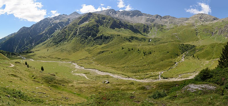
English: Alpine pasture Tauscherböden in the Tauern Valley near Mallnitz, High Tauern National Park, Carinthia, Austria
Español: Pradera alpina Tauscherböden en el valle de Tauern cerca de Mallnitz, Parque Nacional Hohe Tauern, Carintia, Austria.
Polski: Hala Tauscherböden w dolinie Tauern położonej na terenie Parku Narodowego Wysokich Taurów, niedaleko Mallnitz, w Karyntii, w Austrii.
Português: Pradaria alpina Tauscherböden no vale do Tauern perto de Mallnitz, Parque Nacional dos Alpes Tauern, Caríntia, Áustria.
বাংলা: মেলনিজের কাছাকাছি টালার্ন উপত্যকায় অ্যালপিইন চারণভূমি টাউশারবডেন, হাই টাউরেন জাতীয় উদ্যান, কারিন্থিয়া।
Čeština: Alpská pastvina Tauscherböden v údolí u vesnice Mallnitz, Národní park Vysoké Taury, Rakousko.
Italiano: Pascoli alpini Tauscherböden degli Alti Tauri vicino Mallnitz, Parco Nazionale Alti Tauri, Carinzia
Македонски: Планинското пасиште Таушербеден во Таурската Долина. Национален парк Високи Таури, Корушка, Австрија.
|
|||
| Date | ||||
| Source | Own work | |||
| Author | Uoaei1 |

| Camera location | | View this and other nearby images on: OpenStreetMap |
|---|

|
NOTE: This image is a panorama consisting of multiple frames that were merged or stitched in software. As a result, this image necessarily underwent some form of digital manipulation. These manipulations may include blending, blurring, cloning, and colour and perspective adjustments. As a result of these adjustments, the image content may be slightly different from reality at the points where multiple images were combined. This manipulation is often required due to lens, perspective, and parallax distortions.
|
Assessment[edit]
|
This image was selected as picture of the day on Bengali Wikipedia.
|
This image was selected as picture of the day on Wikimedia Commons for 7 August 2017. It was captioned as follows: English: Alpine pasture Tauscherböden in the Tauern Valley near Mallnitz, High Tauern National Park, Carinthia Other languages:
Čeština: Alpská pastvina Tauscherböden v údolí u vesnice Mallnitz, Národní park Vysoké Taury, Rakousko. Deutsch: Tauscherböden im Tauerntal bei Mallnitz, Nationalpark Hohe Tauern, Kärnten English: Alpine pasture Tauscherböden in the Tauern Valley near Mallnitz, High Tauern National Park, Carinthia Español: Pradera alpina Tauscherböden en el valle de Tauern cerca de Mallnitz, Parque Nacional de Hohe Tauern, Carintia, Austria. Italiano: Pascoli alpini Tauscherböden degli Alti Tauri vicino Mallnitz, Parco Nazionale Alti Tauri, Carinzia Polski: Hala Tauscherböden w dolinie Tauern położonej na terenie Parku Narodowego Wysokich Taurów, niedaleko Mallnitz, w Karyntii, w Austrii. Português: Pradaria alpina Tauscherböden no vale do Tauern perto de Mallnitz, Parque Nacional dos Alpes Tauern, Caríntia, Áustria. Македонски: Планинското пасиште Таушербеден во Таурската Долина. Национален парк Високи Таури, Корушка, Австрија. বাংলা : মেলনিজের কাছাকাছি টালার্ন উপত্যকায় অ্যালপিইন চারণভূমি টাউশারবডেন, হাই টাউরেন জাতীয় উদ্যান, কারিন্থিয়া। |
Licensing[edit]
I, the copyright holder of this work, hereby publish it under the following license:
This file is licensed under the Creative Commons Attribution-Share Alike 4.0 International license.
- You are free:
- to share – to copy, distribute and transmit the work
- to remix – to adapt the work
- Under the following conditions:
- attribution – You must give appropriate credit, provide a link to the license, and indicate if changes were made. You may do so in any reasonable manner, but not in any way that suggests the licensor endorses you or your use.
- share alike – If you remix, transform, or build upon the material, you must distribute your contributions under the same or compatible license as the original.
File history
Click on a date/time to view the file as it appeared at that time.
| Date/Time | Thumbnail | Dimensions | User | Comment | |
|---|---|---|---|---|---|
| current | 16:11, 2 November 2016 | | 10,344 × 4,834 (37.73 MB) | Uoaei1 (talk | contribs) | WB |
| 10:06, 25 August 2016 |  | 10,344 × 4,834 (36.26 MB) | Uoaei1 (talk | contribs) | Spot (flying bird) cleaned | |
| 09:52, 25 August 2016 |  | 10,344 × 4,834 (36.26 MB) | Uoaei1 (talk | contribs) | User created page with UploadWizard |
You cannot overwrite this file.
File usage on Commons
The following 31 pages use this file:
- Mallnitz
- User:Anton-kurt/Tyrol new files/2016 August 21-31
- User:Anton-kurt/Tyrol new files/2016 November 1-10
- User:Meiræ/16
- User talk:Uoaei1/Archive05
- Commons:Featured picture candidates/File:Mallnitz Tauerntal Tauscherböden 20160807.jpg
- Commons:Featured picture candidates/Log/September 2016
- Commons:Featured pictures/Places/Natural/Austria
- Commons:Featured pictures/chronological/2016-B
- Commons:Picture of the Year/2016/Candidates
- Commons:Picture of the Year/2016/R1/Gallery/2016-B
- Commons:Picture of the Year/2016/R1/Gallery/ALL
- Commons:Picture of the Year/2016/R1/Gallery/M09
- Commons:Picture of the Year/2016/R1/Gallery/Nature views
- Commons:Picture of the Year/2016/R1/v/Mallnitz Tauerntal Tauscherböden 20160807.jpg
- Commons:Quality images/Subject/Places/Natural structures/Panorama/Archive 2016
- Commons:Quality images candidates/Archives September 02 2016
- Template:Potd/2017-08
- Template:Potd/2017-08-07
- Template:Potd/2017-08-07 (bn)
- Template:Potd/2017-08-07 (cs)
- Template:Potd/2017-08-07 (de)
- Template:Potd/2017-08-07 (en)
- Template:Potd/2017-08-07 (es)
- Template:Potd/2017-08-07 (hu)
- Template:Potd/2017-08-07 (it)
- Template:Potd/2017-08-07 (ko)
- Template:Potd/2017-08-07 (mk)
- Template:Potd/2017-08-07 (nl)
- Template:Potd/2017-08-07 (pl)
- Template:Potd/2017-08-07 (pt)
File usage on other wikis
The following other wikis use this file:
- Usage on be-tarask.wikipedia.org
- Usage on bn.wikipedia.org
- Usage on crh.wikipedia.org
- Usage on cv.wikipedia.org
- Usage on fr.wikipedia.org
- Usage on fy.wikipedia.org
- Usage on hu.wikipedia.org
- Usage on hy.wikipedia.org
- Usage on incubator.wikimedia.org
- Usage on ka.wikipedia.org
- Usage on ko.wikipedia.org
- Usage on krc.wikipedia.org
- Usage on lbe.wikipedia.org
- Usage on lez.wikipedia.org
- Usage on mdf.wikipedia.org
- Usage on mk.wikipedia.org
- Usage on nl.wikipedia.org
- Usage on os.wikipedia.org
- Usage on pt.wikipedia.org
- Usage on ru.wikipedia.org
- Usage on ru.wikinews.org
- Usage on sah.wikipedia.org
- Usage on sq.wikipedia.org
- Usage on tt.wikipedia.org
- Usage on tyv.wikipedia.org
- Usage on udm.wikipedia.org
- Usage on uk.wikipedia.org
- Usage on vep.wikipedia.org
- Usage on vi.wikipedia.org
- Usage on xal.wikipedia.org
- Usage on zh.wikipedia.org