Air traffic control is not just for planes anymore
With thousands of drones taking to the skies every day, the airspace is bound to get crowded. These companies are working to prevent drone disruptions.


- Webby Award honoree, 2x Gold Telly Award winner
When regulations finally catch up to let companies like Amazon and UPS fly drones for delivery purposes, the airspace is going to get pretty crowded. That's even before you add on the tens of thousands of recreational drone flights that take place every day.
Unmanned aircraft systems (UAS) are already causing disruption at airports around the world, and there have been multiple reports of drone-related injuries as pilots have flown into stadiums or crashed into public landmarks.
AirMap, based in Santa Monica, California, is a platform for managing drone traffic.
It aggregates data from a variety of sources that encompass traffic, weather, first-responder activity and regulatory restrictions. Information is used by drones like those from DJI and Yuneec to help prevent pilots from flying where they shouldn't.
Flights at lower-level altitudes have to consider obstacles like buildings and emergency activity, things that commercial airliners generally don't have to worry about at 30,000 feet.
"This is really an index of what's happening in real time, in three dimensions," explains Ben Marcus, CEO of AirMap. "So it is a map for autonomous vehicles… [but] the services have to be usable by human beings as well because human beings are flying the drones."
Before taking off, drone pilots submit a flight plan that's analyzed to tell them about weather conditions or if they are violating any rules in the airspace.
Airports and other airspace managers can also access the data from AirMap and communicate directly with drone pilots who have submitted flight plans and their phone numbers. There are 130 airports in the US, including LAX and Houston's George Bush Intercontinental that are currently using the platform. At the moment the system is totally voluntary and there's no federal requirement for drone pilots to register with AirMap.
Is it a bird or is it a drone?
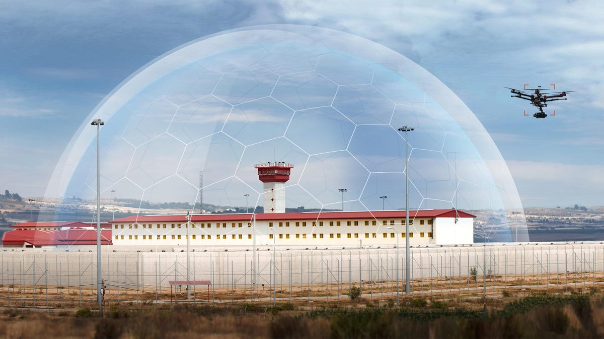
Platforms like AirMap are ideal for drone flights conducted with good intentions. For not-so-well-intentioned flights that might fly around areas like prisons, stadiums or government facilities, another solution is required.
Drone radar is prohibitively expensive for most applications. "It's basically military-grade radars that cost about a million dollars a square mile to cover," explains Kevin Hightower, head of product at AirMap.
Dedrone uses a combination of ground-based hardware, including an RF sensor and video camera, and software to detect an errant drone entering sensitive airspace.
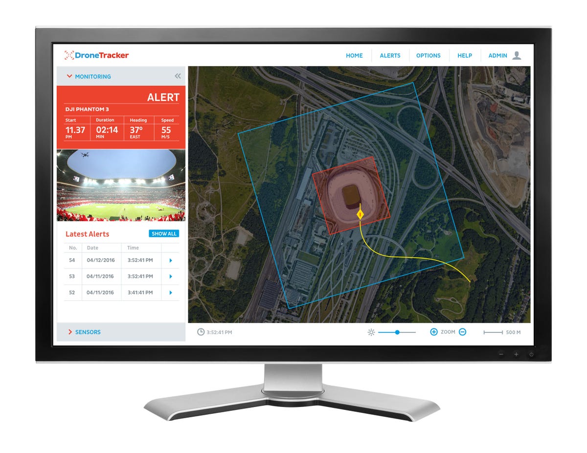
Dedrone's web interface where users can track the characteristics and path of a drone.
The system can match the characteristics of a flying object against entries in what the company calls a drone DNA database. It's made up of several components, including the communication technology that helps classify and profile drones.
"Another is an image recognition database that includes images of drones and other objects," says Pablo Estrada, VP of marketing at Dedrone. Those other objects could be birds, trees, frisbees or dogs. "Drones fly in a pretty different manner than, say, a bird or an airplane."
Currently the DNA database contains over 1 million images. Once the system detects a drone, a red rectangle overlaid on the video feed follows its movements in real-time. The software can also provide a predicted flight path to work out where it might go next.
Then, it's up to the customer to integrate this detection into a wider security process.
"You may want do things like turn off different parts of your network infrastructure if you're concerned about data hacking, or perhaps close windows and blinds, if you're concerned about privacy and the high resolution cameras," says Estrada.
Even something as simple as shining a flashlight at the drone can be effective. "If the pilot sees that flash of light coming from the building or facility, then they will typically be scared away, knowing that they have been detected," he explains.
It's illegal in the US for people or private companies to use jamming technology because of FAA and FCC regulations. But Dedrone does integrate with jamming manufacturers so users like government agencies or military institutions who have authority to use the technology can implement security measures.
More than just drones
Tech companies are already making inroads into other flying vehicles, including flying cars. Uber has detailed plans for the Elevate project, Amazon is working out the regulatory requirements for its drone-based delivery service Prime Air, and Larry Page 's human hovercraft KittyHawk is due to go on sale at the end of 2017.
These vehicles adds yet another layer of complexity to the drone landscape. Marcus gives an example of a drone flying at low altitudes through a city where it would be helpful to understand traffic flows of where pedestrians walk. "Those vehicles extend into urban environments, flying close to airports, flying in high densities with other vehicles. Our capabilities that we've developed for drones apply just the same to flying cars."
On a broader level, NASA and the FAA have been testing an air-traffic control system specifically for UAS like drones. It aims to manage the airspace so flight paths can be adjusted on the fly to avoid collisions. But this research is not due for completion until 2019, and it could be 2025 before any regulations are fully implemented.