Just a few months after receiving approval to begin tunneling from the SpaceX parking lot into Los Angeles, Elon Musk and The Boring Company have released a map that shows a conceptual layout for tunnels throughout the city. None of this is official and will require approval from Los Angeles County, the City of Los Angeles, and other city Governments in the county area, but serve as a basis for feedback from said governments and the public. This could be our first real preview as to what the layout of the tunneling system will be like upon completion. Let’s take a better look at it!
Long Beach to Sherman Oaks; LAX to Dodger Stadium

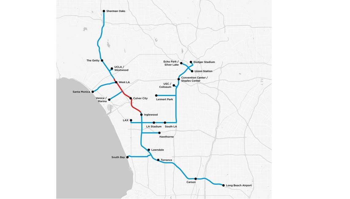
As you can see, Musk and the Boring Company have been hard at work connecting the dots, if you will. The longest part of the map stretches from Long Beach Airport in the southeastern corner of LA County all the way to Sherman Oaks Neighborhood, just north of downtown Los Angeles. For those of you not familiar with the area, this is practically the same route of the 405 and would also allow for smaller tunnels to connect areas like Santa Monica, South Bay, LAX, and SpaceX’s home, Hawthorne, among many others. There’s also a route from LAX all the way to Dodger Stadium, running roughly the same path as State Route 110.
So, at this point, you’re probably wondering about the difference between the red and blue tunnels. Well, the idea is that The Boring Company will dig out a conceptual tunnel that runs pretty much between Inglewood and West L.A. This portion of the tunnel will serve as a testbed for verification of construction logistics, operating procedure development, line-switching demonstrations, safety testing, and overall system testing. This is considered phase one, and wouldn’t be used for public transportation purposes until the tunnel construction, safety, and operation is approved not only by the Boring Company but by the county and city governments as well.
Phase two, which are represented by the blue tunnels, is the proposed routes that may or may not happen after the fact. Should the public, various governments approve this exact map, all of these tunnels could eventually be dug out and connected to allow high-speed travel. However, they will likely change at some point as feedback comes in from various sources. For what it’s worth, I wouldn’t expect to see the map change much as it seems to connect most of the important areas, including UCLA, Venice, LAX, and even USC and the LA Stadium. Should Phase 1 go according to plan, I’d expect to see Musk push for the digging south first toward LAX and Hawthorn while other crews would complete the North tunnels. Once the areas practically under the 405 are in operation, the remaining tributary tunnels will be dug out in priority of most-needed to least-needed at the time.
What do you guys think? Do these proposed tunnels look like they will do the trick? Where would you like to see entrance and exit points along the path? Let us know in the comments section below.
References
Read more about Hyperloop One.
Read more about The Boring Company.
Read more about Elon Musk.