Predicting Chaos: New Sensors Sniff Out Volcanic Eruptions Before They Happen
How volcanologists brave lung-singeing fumes to monitor eruptions with cutting-edge sensors
/https://tf-cmsv2-smithsonianmag-media.s3.amazonaws.com/filer/52/d4/52d4a53c-6a65-450e-b098-c0ef9c341d19/volcano_image_3.jpg)
Volcanoes have blindsided humans for millennia, leaving entire cities at the whim of their devastating eruptions. But compared to other forms of natural disaster, volcanoes actually offer a variety of quiet clues leading up to their destruction. Now, new developments in volcano monitoring systems allow scientists to sniff out, forecast and plan for eruptions with more precision than ever before.
“We are now able to put really precise instruments on volcanoes to monitor the types of gases that are emitted, and that gives us a clue as to where magma is in the system,” says Marie Edmonds, a volcanologist at the University of Cambridge who has been working amongst fuming volcanoes for about 15 years. “We can see trends in the data relating to eruptions that are just about to happen.”
Edmonds is part of an international group called the Deep Carbon Observatory that is working to place newly developed gas sensors on 15 of the 150 most active volcanoes on Earth by 2019, to improve their capacity to forecast different types of eruptions worldwide. Last week the Deep Carbon Observatory released an interactive visualization, supported in part by the Smithsonian Institution’s Global Volcanism Program, that allows the public to watch visualizations of historic volcanic data evolve through time.
The visualization also lets viewers follow along as new sensors are deployed. These sensors continuously measure carbon dioxide, sulfur dioxide and water vapor fuming out of volcanoes, and are placed within large boxes and buried underground with antennae on the surface. In recent years, advancements in electronics have made them more precise and affordable, allowing scientists to use them more prevalently around he world.
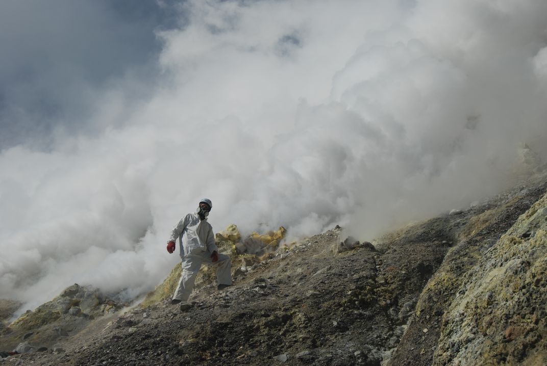
Yet placing these sensors on top of active volcanoes isn’t without risk. Researchers must wear reflective suits to protect their skin from excess heat, and gas masks to protect their lungs from getting singed by corrosive gases—sometimes after hiking long distances through remote regions to reach a site. But Edmond says the potential good such work can do for populations at risk makes the more dangerous parts of the job worthwhile.
“It’s brilliant to know that you are doing something to actually help people,” says Edmonds. “You do think about what you’re doing because it is sometimes dangerous, but I really do enjoy it.”
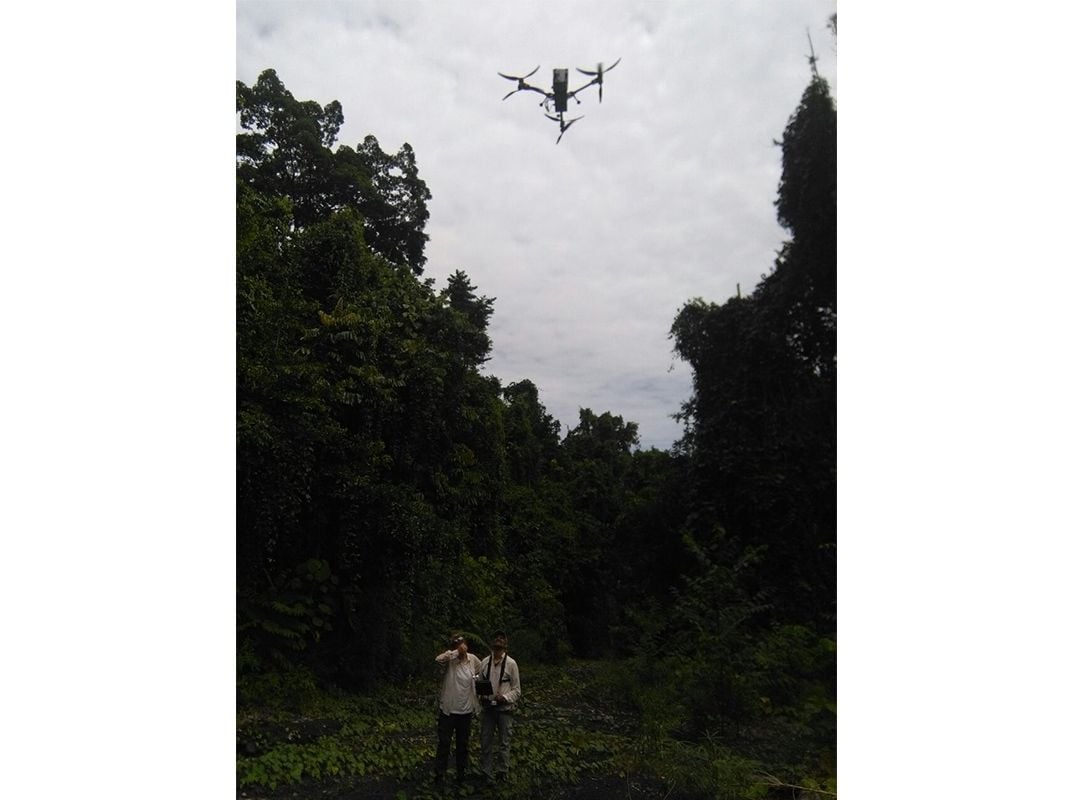
In the past month, researchers from Edmonds’ team attached one of their sensors on a drone and measured emissions from a remote volcano in Papau New Guinea over a short period of time, demonstrating another recently-developed technique used to collect snapshots of volcanic activity. When collected over a range of different types of volcanoes, these snapshots help scientists better understand the complexities of the activities leading up to an eruption. (What drones can't do, however, is take long-term measurements.)
Gas sensors help forecast eruptions because, as magma rises up, the resulting release of pressure overhead uncorks gases dissolved within the magma. Carbon dioxide billows out relatively early on and, as magma slithers higher up, sulfur dioxide begins to fume out. Researchers use the ratio of these two gases to determine how close the magma is getting to the earth’s surface, and how imminent an eruption may be.
As magma rises, it also pushes through rock in the crust and causes tiny earthquakes not usually felt by humans above, but detectable with sensitive seismic equipment. Edmonds’ team often pairs gas sensors with seismic stations and uses the data in tandem to study volcanoes
Robin Matoza, a researcher at the University of California at Santa Barbara who is not involved in Edmond’s research, agrees that technological advancements in recent years have drastically improved researchers’ ability to understand the inner workings of volcanoes and the behaviors leading up to eruptions. In places where his team once had just a few seismic stations, they can have now installed 10 or more due to the smaller size and increasing affordability of the technology. The ability to compute the collected data has also improved in recent years, Matoza says.
“Now we are easily able to store years worth of seismic data just on a small flash drive,” says Matoza, who studies seismic signals released by volcanoes prior to eruptions. “So we can easily query that large data and learn more about the processes contained in it.”
To supplement gas and seismic information on a broader scale, researchers use satellites to study eruptions from above. Volcanologists at the Alaska Volcano Observatory in Anchorage and Fairbanks collect this suite of gas, seismic and satellite data to on a regular basis, monitoring roughly 25 volcanoes across the state and offer early warnings to residents.
For example, they released a series of warnings in the months leading up to the 2009 eruption of Mount Redbout, about 110 miles (180 km) southwest of Anchorage. They also work closely with the Federal Aviation Administration to help detect aviation hazards during eruptions.
Over time, the researchers agree that satellites will become increasingly useful in collecting data over large regions. But at the moment, satellites are less precise and not as reliable as the other tools, in part because they don’t collect data as rapidly and don’t function well during cloudy weather.
“You can have a satellite pass over a volcano and it can be obscured by clouds,” says Matt Haney, a volcanologist at the Alaska Volcano Observatory. “I imagine in the future there will be new satellites that are launched that will be even more powerful.”
Despite the challenges of this work, Edmonds says it can be easier to forecast volcanic eruptions than some other hazards because of the array of warning signs preceding eruptions compared to certain earthquakes and other abrupt disasters. And while the researchers may not be able to forecast to the exact day or hour that an eruption will occur yet, rapidly advancing technology is moving them in that direction.
“The more instruments and the more sensors just contribute to our toolbox,” says Edmonds. “We are one step closer.”