
Riddagshausen Abbey
.jpg)
Riddagshausen Abbey (German: Kloster Riddagshausen) was a Cistercian monastery just outside the city of Brunswick in Germany.
History[edit]
It was founded as Marienzelle by Ludolf the Wend, a ministerialis of Henry the Lion and steward of Brunswick, and settled in 1145 by monks from Amelungsborn Abbey. Henry endowed the new foundation in 1146 with the neighbouring village of Riddagshausen, from which it took its name.[1]
The abbey early acquired reichsunmittelbar status as an Imperial abbey.[1]
It was mediatised in 1569 by Brunswick-Wolfenbüttel, when it became a Protestant establishment.[1] From 1690 it was also the home of a prestigious Lutheran seminary for training of preachers, the first in Germany. The religious community and the seminary were dissolved in 1809.[2][3]
Description[edit]
The site, now included within the city of Brunswick, in the district of Wabe-Schunter-Beberbach, is now mostly a nature reserve[4] and arboretum.[5] The nature reserve Riddagshäuser Teiche is designated as Important Bird Area[6] and Special Protection Area.[7]
The surviving buildings include the abbey church[8] and the gatehouse, now home of the Cistercian Museum.[9]
-
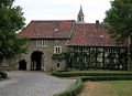 Gatehouse
 -
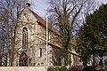 Church
 -
 Church, interior
 -
 Riddagshausen Abbey in the 17th century


Notes and references[edit]
- ^ a b c Klosterkirche Riddagshausen: history (in German)
- ^ The seminary was however refounded in 1837 and after a century in various premises in Wolfenbüttel and closure because of World War II, was eventually re-established in Brunswick in 1952, although in the town's former Franciscan friary, not in Riddagshausen Abbey.
- ^ Theological seminary formerly in Riddagshausen Abbey
- ^ BUND Kreisgruppe Braunschweig
- ^ www.tu-bs.de[permanent dead link]
- ^ BirdLife Data Zone. Retrieved on November 4, 2012.
- ^ EUNIS Site factsheet. Retrieved on November 4, 2012.
- ^ KlosterkircheRiddagshausen.de
- ^ Zisterziensermuseum website
External links[edit]
- (in German) Riddagshausen: local history and photo gallery
- (in German) Riddagshausen Abbey photo gallery
- (in German) Riddagshausen Abbey photos
52°16′03″N 10°34′38″E / 52.267386°N 10.577264°E
| International | |
|---|---|
| National | |
| Geographic | |
| Other | |
- Cistercian monasteries in Germany
- Imperial abbeys
- Monasteries in Lower Saxony
- 1140s establishments in the Holy Roman Empire
- 1145 establishments in Europe
- Religious organizations established in the 1140s
- Lutheran seminaries
- Christian monasteries established in the 12th century
- Churches in Braunschweig
- History of Brunswick
- Museums in Lower Saxony
- Important Bird Areas of Germany
- Special Protection Areas
- Lutheran churches in Lower Saxony
- Duchy of Brunswick
- Lutheran universities and colleges in Europe