
Map of the areas susceptible to massive flooding if the Lewisville Dam were to breach, including downtown Dallas, Coppell (where I live), Carrollton, Farmer’s Branch, Irving, Love Field, the Hospital Disctrict. Here is the article:
Related Posts


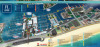

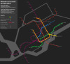


Map of the areas susceptible to massive flooding if the Lewisville Dam were to breach, including downtown Dallas, Coppell (where I live), Carrollton, Farmer’s Branch, Irving, Love Field, the Hospital Disctrict. Here is the article:
 fantodsdhrit liked this
 :V woah, it’s my house
 historyman2006 reblogged this from mapsontheweb willpgh liked this
  daveytunes72 liked this
  pgoodmood liked this
  magnusnphil reblogged this from mapsontheweb magnusnphil liked this
  inner-ecosystem reblogged this from mapsontheweb
  genunchiilumii liked this historyman2006 submitted this to mapsontheweb