Nobody likes being stuck in an airport by a cascade of cancelled flights, uncertainly adrift in the vagaries of rescheduling. These circumstances are usually brought about by lousy weather, as many travelers in the US were reminded over the holidays. But that’s not the only monkey wrench in Mother Nature’s bag of tricks.
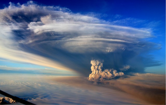
Erupting volcanoes can hurl up huge clouds of ash made of microscopic particles of volcanic glass, a situation that creates a serious risk for airplane engines. Eruptions of Iceland’s Eyjafjallajökull in 2010 and Grímsvötn in 2011 each wreaked havoc on the air travel system as flights were diverted around their ash clouds. A group of researchers led by Sigrún Hreinsdóttir studied data collected during the Grímsvötn eruption, and they think they may have discovered something that could help: a way to improve forecasts of how that dangerous plume of ash will change over time.
The volcanic mouth of Grímsvötn sits beneath an ice cap, with only one point of rock along its rim piercing the glacial mantle. A very precise GPS station and a device that measures tilting sit on that point to help monitor the volcano’s behavior. Volcanoes like Grímsvötn actually swell a bit while the magma chamber fills and pressurizes—until the pressure is so great that they erupt.
During the eruption, the volcano “deflates.” Just as a beach ball collapses more quickly if the air inside it escapes quickly, the rate that the volcano deflates tells you something about what’s going on inside its red-hot guts. The researchers wanted to see how well that deflation rate corresponded to the height of the erupting ash plume, which is determined by the velocity with which the ash is launched from the volcano.
About an hour before the eruption began, the station began sinking rapidly, losing about 10 centimeters of elevation by the time it started. After that, the rate of sinking matched beautifully with the height of the ash plume, as determined by radar stations. The plume gradually dropped from its initial high of 20-25 km over the week that the eruption lasted, but with occasional spasms bringing it close to its former stature.
A simple mathematical model was used to turn the GPS data into predictions of plume height. The fact that it did such an excellent job of reproducing reality shows that activity in the guts of the volcano—what volcanologists call “the plumbing”—was pretty simple, too. Any of a number of things could potentially have made for a more complex eruption: multiple batches of magma could have risen up to refuel the eruption, changing the character of the magma chamber at the same time; new pathways could have opened up and rerouted the plumbing. The compressibility of the magma also didn’t change much, even though gas was being released from it the whole time—an interesting detail to researchers.
This information will help researchers understand what to expect the next time Grímsvötn blows, which it does pretty frequently. There and elsewhere, real-time data like this could provide warning of an imminent eruption (beyond the heightened seismic activity that typically precedes eruptions) and give us a better idea of how the ash plume high above the volcano is going to behave. Other volcanoes may be a little more unruly, complicating those efforts somewhat, but more information can only help those in charge of keeping the air travel system safely moving.
Nature Geoscience, 2014. DOI: 10.1038/NGEO2044 (About DOIs).
Reader Comments (15)
View comments on forumLoading comments...