Home & Garden
Cold Thursday and Friday, Much Colder for the Weekend in Tarrytown, Sleepy Hollow
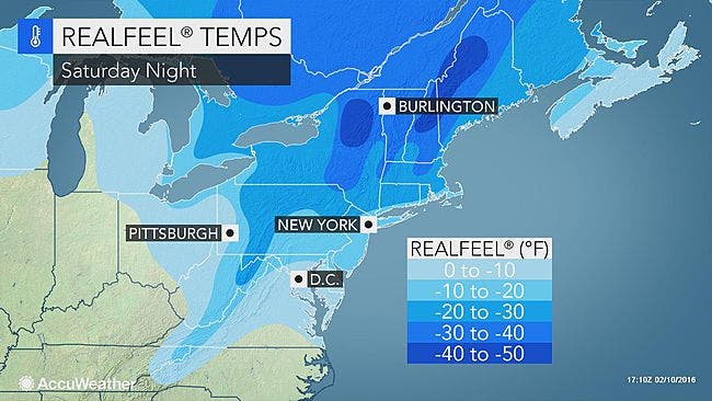
Dangerous wind chills can be expected for Saturday.

Yes, it’s going to be cold Thursday and Friday, but as they say, you ain’t seen nothin’ yet.
The National Weather Service has issued a Hazardous Weather Outlook for Putnam, Rockland and Westchester counties for Thursday through Wednesday of next week.
Click here for Tarrytown and Sleepy Hollow’s in-depth weather forecast.
The NWS said there could be locally heavy snow showers that could reduce visibility and produce a “quick coating of slippery accumulation on area roadways.”
If you want to consider that the “good news,” then the “bad news” is that beginning Friday night temperatures are going to plummet.
The weather service said temps falling to zero to 5-below will be combined with sustained winds that will mean wind chills of around 25-below late Saturday night into early Sunday morning.
Bill Potter of HudsonValleyWeather.com said, “Thursday and Friday will certainly be cold… but the 2nd wave of artic air, is pure… polar… air, and it arrives just before dawn on Saturday. The coldest air since last winter is on the way. Temps will start out in the mid teens on Saturday… and likely not move much during the day. A gusty northwest wind will make it feel like 0° during the afternoon hours… a very ugly day lined up. Then Saturday night… the bottom drops out, and we play temperature limbo to see ‘how low can we go?’ ”
The Forecast
So for today, the lower Hudson Valley could see some light snow before 2 p.m. or 3 p.m. The high will be in the upper 20s, but with the wind chill, it will feel more like 5 to 10 degrees.
Snow accumulations of less than half an inch are possible.
Thursday night, the skies will be clear to mostly clear and the temperature will go down to the upper single digits to the low teens.
Again, the wind chill factor will make it feel close to zero.
For Friday, the temperature rebounds to the mid-20s but the wind chill will make it feel closer to 10 degrees or lower.
There is a chance of snow after 4 p.m. Friday.
Friday night will see another chance of snow showers before midnight, with temperatures on either side of 13 degrees.
Saturday’s skies will be cloudy, then turning sunny. However, the temperature will be in the mid-teens.
With winds ranging from 25 mph to 30 mph, it will feel much colder. Gusts could be up to 40 mph or more.
Extreme cold in the negative single digits can be expected Saturday night.
Get more local news delivered straight to your inbox. Sign up for free Patch newsletters and alerts.

