The Mystery of the Appalachian Bend

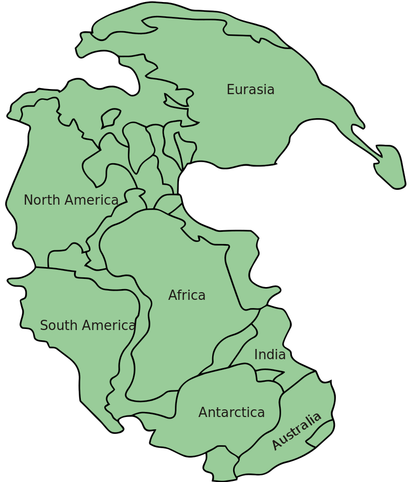
Three hundred million years ago, the Earth looked a lot different than it did today. We still had oceans and land (and the term “we” is used loosely as there were no people around back then), but everything was a smushed together, at least relative to today’s maps. The land was collected in a supercontinent, as seen above, which we today often refer to as Pangea. (If you want a map of Pangea with relatively current political borders, click here. Your area probably has different neighbors than you do today.)
Over the eons, everything moved, forming the continents we have today. But moving land masses isn’t a simple, delicate thing. Tectonic plates ram into each other, causing massive changes in the landscape along the way. When North American and African continental plates rammed into each other, for example, they created the Appalachian Mountains which run up the eastern part of the current North American Continent.
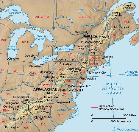
As seen in the map above, the Appalachians run in a straight line from Newfoundland southward until they hit (roughly) the New York/New Jersey/Pennsylvania border. At that point, the range bends westward, continuing straight again until it peters out in northern Alabama. The bend, though, shouldn’t be there — or, at least, geologists were at a loss for years as to why it formed. When the two continental plates collided, there was no such bend. Geologists figured that something got in the way, but as none of us were around to watch these mountains slowly emerge, it was unclear what that roadblock was.
But now we know. The key clue: A little bit of extra gravity.
We think of the earth’s gravitational field as uniform, pulling us downward equally whether we’re in New York or New Zealand. That’s not quite right, though. As Indiana Public Media’s “A Moment of Science” notes, “when gravity is measured, we find it changes from place to place. That is because the density and thickness of Earth’s rock layers is not the same everywhere. Certain parts of the earth are denser than others, causing the gravitational pull to be slightly greater in those places.” And guess what? When one measures the gravity around the Appalachian Bend, one finds that the gravitation pull is a bit higher than it elsewhere along the mountain chain. Here’s a third map, via the University of Rochester.
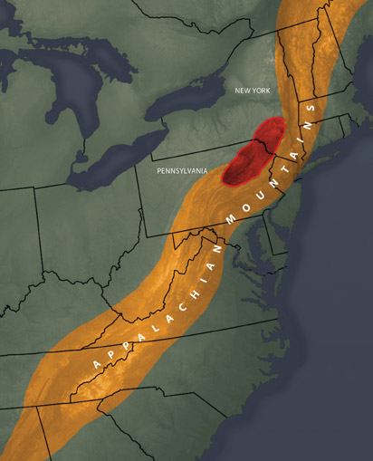
That red area, which nicely corresponds to where the bend is located, is the area where gravity is stronger — and therefore, is probably home to something of high density waiting quietly underground. (Don’t worry, it’s not a monster or anything.) By using “data on the changes in gravitational pull and seismic velocity together,” the research team at the University of Rochester was able “to determine the density of the underground structure and conclude that it is volcanic in origin, with dimensions of 450 kilometers by 100 kilometers.” And hundreds of millions of years ago, it was there, too.
So what happened way back when? Effectively, a rock — or two rocks, in the form of colliding continental plates — met a hard place, in the form of an ancient, gravity-manipulating volcanic structure the size of Taiwan. And in this case, the hard place won, as the continental plates diverged their collision course, bending around the rock in their way.
 Bonus Fact: If parts of Appalachia have slightly more gravity than most of the Earth, then it’s likely that other parts of the Earth have less of a gravitational pull, right? Right! If you travel to the Indian Ocean, just south of Sri Lanka, you’ll end up in a region known as having “the largest and most striking feature in the gravitational field of the earth” (per this paper hosted by NASA, at least). Here’s a map of places where the gravitational field is anomalous, and you’ll note that the area near Sri Lanka is much different than the rest of the planet. (You may also note that the Appalachian area discussed above isn’t sufficiently different from the rest of the world to register on the map.) A brief explanation as to how the map was created can be found here.
From the Archives: Just Say No to Gravity: The people who tried to stop gravity. Really.
Take the Quiz: Name a country that the provided mountain ranges are in.
Related: A great toy called a “gravity maze.” It’s like a tangible, 3-D app which does not require batteries (but definitely requires some critical thinking skills).