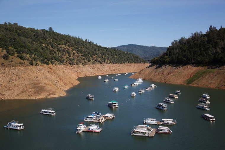
OROVILLE, California— The view from Lake Oroville, nestled in the foothills of Northern California, is stunning.
The massive reservoir has 167 miles of snaking shoreline. In many areas the lake is hundreds of feet deep, capable of holding 3.5 million acre-feet of water.
But what may be most astonishing is what you don’t see here: The water level has plummeted nearly 200 feet in some areas. Vast hills and rolling valleys of brown, which used to be covered in water, now tower out of the lake bed.
It’s a troubling sign for all of California, and symbolic of the devastating drought in the West. Oroville is the second largest reservoir in the region, supplying cities like San Francisco and Los Angeles with water used for drinking, irrigation, and even fighting fires.
Scientists say it would take 11 trillion gallons of water the pull the state out of this crippling drought, and when you see Oroville — especially with a drone’s perspective — you can see how big of a hole the region is in.
In all there are 12 major reservoirs scattered across the Golden state. Each one plays a critical role in water supply and distribution. But the water levels at each one sit well below the historic average for this time of the year. Some of the largest reservoirs are operating at just a small fraction of capacity.
California won’t run out of water anytime soon — but, with many experts saying there's no sign the drought will quickly — what we see at reservoirs is an indicator the region is in serious trouble.
Governor Jerry Brown as already declared a state of emergency in California — and he’s ordered everyone in the state to cut their water used by 25 percent. But that goal hasn't been meet. And in the meantime water levels continue to sink at reservoirs.
Oroville, like many of the other lakes in the region, is feed two ways: 1) by melting snow pack … 2) by major storms. But with a dismal snow season, and hot, dry weather in the forecast, there is little relief on the horizon.
Covering this historic drought for the last 4 years, I’ve seen some dramatic images emblematic of the West’s current crisis. With a drone the view is both breath taking — and alarming. California looks to be in serious trouble.

